Robion elevation
Robion (Provence-Alpes-Côte d'Azur, Département du Vaucluse), France elevation is 125 meters and Robion elevation in feet is 410 ft above sea level [src 1]. Robion is a populated place (feature code) with elevation that is 49 meters (161 ft) smaller than average city elevation in France.
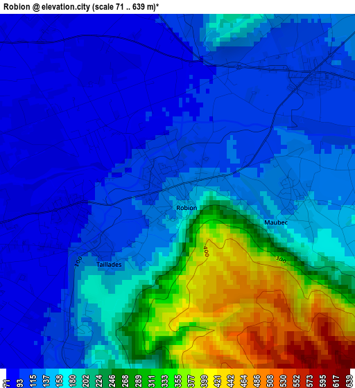
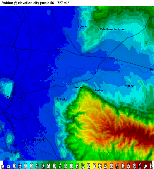
Below is the Elevation map of Robion, which displays elevation range with different colors. Scale of the first map is from 71 to 639 m (233 to 2096 ft) with average elevation of 174.9 meters (=574 ft) [note 1]
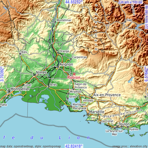
These maps also provides idea of topography and contour of this city, they are displayed at different zoom levels. More info about maps, scale and edge coordinates you can find below images.
| \ | Map #1 | Map #2 | Topo.Map |
| Scale [m] | 71..639 m | 56..727 m | × |
| Scale [ft] | 233..2096 ft | 184..2385 ft | × |
| Average | 174.9 m = 574 ft | 189.9 m = 623 ft | × |
| Width | 7.05 km = 4.4 mi | 14.1 km = 8.8 mi | 225.5 km = 140.1 mi |
| Height | 7.05 km = 4.4 mi | 14.1 km = 8.8 mi | 225.5 km = 140.1 mi |
| ↑Max Latitude | 43.878655° | 43.910322° | 44.85252° |
| Latitude at center | 43.84697° | 43.84697° | 43.84697° |
| ↓Min Latitude | 43.815269° | 43.78355° | 42.82418° |
| ← Min Longitude | 5.066225° | 5.022279° | 3.70392° |
| Longitude center | 5.11017° | 5.11017° | 5.11017° |
| →Max Longitude | 5.154115° | 5.198061° | 6.51642° |
Nearby cities:
Cities around Robion sort by population:
• Cavaillon elevation 71 m
6.2 km,  253°
253°
• L’Isle-sur-la-Sorgue 66 m
9.4 km,  329°
329°
• Sénas 96 m
11.8 km,  192°
192°
• Cheval-Blanc 83 m
6.3 km,  217°
217°
• Orgon 97 m
8.5 km, 222°
• Gordes 296 m
10.2 km,  44°
44°
• Taillades 113 m
2 km,  237°
237°
• Maubec 134 m
2.4 km,  98°
98°
• Lagnes 111 m
5.2 km,  3°
3°
• Goult 217 m
10.9 km,  80°
80°
• Oppède le Vieux 242 m
4.6 km,  116°
116°
• Ménerbes 237 m
7.9 km, 101°
Multilingual:
 En español:
Robion elevación 125 m.
 En France:
Robion élévation 125 m.


Sources and notes:
- [note 1] Map square and city borders are not equal. Map elevation data is calculated only from area inside that square.
- [src 1] Elevation data from geonames database provided with same terms of usage.
- [src 2] The elevation map of Robion is generated using elevation data from NASA's 3 arcsec (90m) resolution SRTM data.
- [src 3] Base (background) map © OpenStreetMap contributors tiles are generated by Geofabrik and OpenTopoMap.
Copyright & License:
This Robion Elevation Map is licensed under CC BY-SA. You may reuse any part from this page, if you give a proper credit by linking to this URL:
 More info on terms of use page.