Rougemont-le-Château elevation
Rougemont-le-Château (Bourgogne-Franche-Comté, Territoire de Belfort), France elevation is 460 meters and Rougemont-le-Château elevation in feet is 1509 ft above sea level [src 1]. Rougemont-le-Château is a populated place (feature code) with elevation that is 286 meters (938 ft) bigger than average city elevation in France.
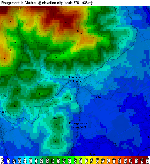
Below is the Elevation map of Rougemont-le-Château, which displays elevation range with different colors. Scale of the first map is from 378 to 938 m (1240 to 3077 ft) with average elevation of 517 meters (=1696 ft) [note 1]
These maps also provides idea of topography and contour of this city, they are displayed at different zoom levels. More info about maps, scale and edge coordinates you can find below images.
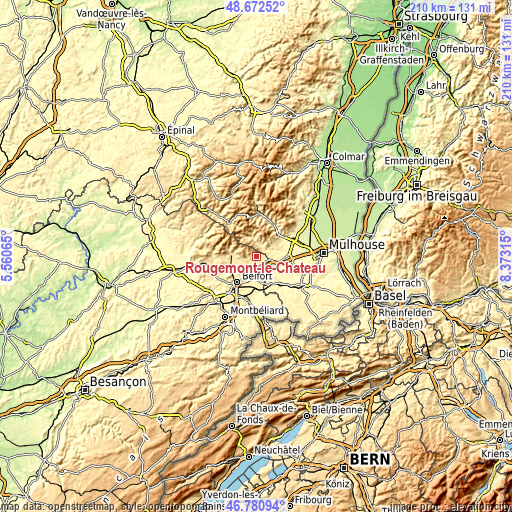
| \ | Map #1 | Topo.Map |
| Scale [m] | 378..938 m | × |
| Scale [ft] | 1240..3077 ft | × |
| Average | 517 m = 1696 ft | × |
| Width | 6.57 km = 4.1 mi | 210.3 km = 130.7 mi |
| Height | 6.57 km = 4.1 mi | 210.3 km = 130.7 mi |
| ↑Max Latitude | 47.764867° | 48.67252° |
| Latitude at center | 47.73532° | 47.73532° |
| ↓Min Latitude | 47.705756° | 46.78094° |
| ← Min Longitude | 6.922955° | 5.56065° |
| Longitude center | 6.9669° | 6.9669° |
| →Max Longitude | 7.010845° | 8.37315° |
Nearby cities:
Cities around Rougemont-le-Château sort by population:
• Thann elevation 335 m
13 km,  51°
51°
• Valdoie 401 m
11.8 km,  232°
232°
• Offemont 378 m
10.5 km,  219°
219°
• Masevaux 407 m
5.1 km,  25°
25°
• Giromagny 489 m
10.5 km,  274°
274°
• Bitschwiller-lès-Thann 418 m
13.4 km,  38°
38°
• Burnhaupt-le-Haut 300 m
13.3 km,  91°
91°
• Sentheim 356 m
6.8 km,  70°
70°
• Chèvremont 348 m
12.3 km,  196°
196°
• Guewenheim 333 m
9.6 km,  78°
78°
• Aspach-le-Haut 311 m
13.1 km, 69°
• Lepuix 509 m
11.7 km,  283°
283°
Multilingual:
 En español:
Rougemont-le-Château elevación 460 m.
 En France:
Rougemont-le-Château élévation 460 m.
 Auf Deutsch:
Rougemont-le-Château höhe über dem Meeresspiegel ist 460 m.
 На русском:
Rougemont-le-Château высота над уровнем моря 460 м
Sources and notes:
- [note 1] Map square and city borders are not equal. Map elevation data is calculated only from area inside that square.
- [src 1] Elevation data from geonames database provided with same terms of usage.
- [src 2] The elevation map of Rougemont-le-Château is generated using elevation data from NASA's 3 arcsec (90m) resolution SRTM data.
- [src 3] Base (background) map © OpenStreetMap contributors tiles are generated by Geofabrik and OpenTopoMap.
Copyright & License:
This Rougemont-le-Château Elevation Map is licensed under CC BY-SA. You may reuse any part from this page, if you give a proper credit by linking to this URL:
 More info on terms of use page.