Valdoie elevation
Valdoie (Bourgogne-Franche-Comté, Territoire de Belfort), France elevation is 401 meters and Valdoie elevation in feet is 1316 ft above sea level [src 1]. Valdoie is a populated place (feature code) with elevation that is 227 meters (745 ft) bigger than average city elevation in France.
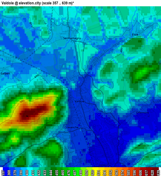
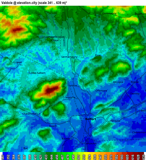
Below is the Elevation map of Valdoie, which displays elevation range with different colors. Scale of the first map is from 357 to 639 m (1171 to 2096 ft) with average elevation of 409.9 meters (=1345 ft) [note 1]
These maps also provides idea of topography and contour of this city, they are displayed at different zoom levels. More info about maps, scale and edge coordinates you can find below images.
| \ | Map #1 | Map #2 | Topo.Map |
| Scale [m] | 357..639 m | 341..639 m | × |
| Scale [ft] | 1171..2096 ft | 1119..2096 ft | × |
| Average | 409.9 m = 1345 ft | 410.6 m = 1347 ft | × |
| Width | 6.58 km = 4.1 mi | 13.16 km = 8.2 mi | 210.6 km = 130.9 mi |
| Height | 6.58 km = 4.1 mi | 13.16 km = 8.2 mi | 210.6 km = 130.9 mi |
| ↑Max Latitude | 47.699994° | 47.729561° | 48.60879° |
| Latitude at center | 47.67041° | 47.67041° | 47.67041° |
| ↓Min Latitude | 47.640809° | 47.611191° | 46.71485° |
| ← Min Longitude | 6.798085° | 6.754139° | 5.43578° |
| Longitude center | 6.84203° | 6.84203° | 6.84203° |
| →Max Longitude | 6.885975° | 6.929921° | 8.24828° |
Nearby cities:
Cities around Valdoie sort by population:
• Belfort elevation 363 m
3.3 km,  164°
164°
• Bavilliers 361 m
5.4 km,  185°
185°
• Offemont 378 m
2.8 km,  107°
107°
• Danjoutin 367 m
6 km,  165°
165°
• Giromagny 489 m
8.1 km,  352°
352°
• Essert 394 m
4.5 km,  204°
204°
• Salbert 420 m
2.2 km,  267°
267°
• Cravanche 374 m
2 km, 201°
• Chèvremont 348 m
7.5 km,  127°
127°
• Andelnans 347 m
7.7 km, 166°
• Châlonvillars 375 m
5.5 km,  232°
232°
• Frahier-et-Chatebier 420 m
6.9 km, 266°
Multilingual:
 En español:
Valdoie elevación 401 m.
 En France:
Valdoie élévation 401 m.


Sources and notes:
- [note 1] Map square and city borders are not equal. Map elevation data is calculated only from area inside that square.
- [src 1] Elevation data from geonames database provided with same terms of usage.
- [src 2] The elevation map of Valdoie is generated using elevation data from NASA's 3 arcsec (90m) resolution SRTM data.
- [src 3] Base (background) map © OpenStreetMap contributors tiles are generated by Geofabrik and OpenTopoMap.
Copyright & License:
This Valdoie Elevation Map is licensed under CC BY-SA. You may reuse any part from this page, if you give a proper credit by linking to this URL:
 More info on terms of use page.