Saint-Amand-sur-Sèvre elevation
Saint-Amand-sur-Sèvre (Nouvelle-Aquitaine, Département des Deux-Sèvres), France elevation is 161 meters and Saint-Amand-sur-Sèvre elevation in feet is 528 ft above sea level [src 1]. Saint-Amand-sur-Sèvre is a populated place (feature code) with elevation that is 13 meters (43 ft) smaller than average city elevation in France.
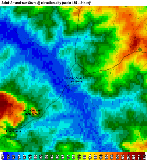
Below is the Elevation map of Saint-Amand-sur-Sèvre, which displays elevation range with different colors. Scale of the first map is from 135 to 214 m (443 to 702 ft) with average elevation of 159.8 meters (=524 ft) [note 1]
These maps also provides idea of topography and contour of this city, they are displayed at different zoom levels. More info about maps, scale and edge coordinates you can find below images.
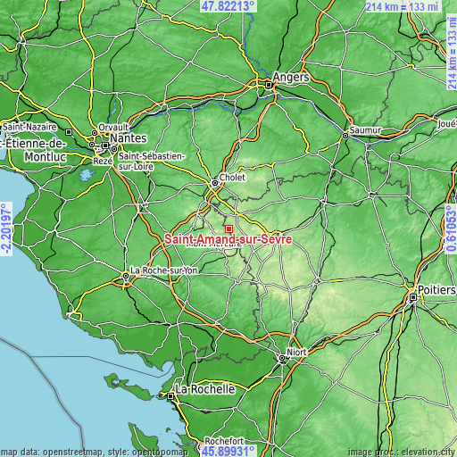
| \ | Map #1 | Topo.Map |
| Scale [m] | 135..214 m | × |
| Scale [ft] | 443..702 ft | × |
| Average | 159.8 m = 524 ft | × |
| Width | 6.68 km = 4.2 mi | 213.8 km = 132.8 mi |
| Height | 6.68 km = 4.2 mi | 213.8 km = 132.8 mi |
| ↑Max Latitude | 46.899365° | 47.82213° |
| Latitude at center | 46.86933° | 46.86933° |
| ↓Min Latitude | 46.839278° | 45.89931° |
| ← Min Longitude | -0.839665° | -2.20197° |
| Longitude center | -0.79572° | -0.79572° |
| →Max Longitude | -0.751775° | 0.61053° |
Nearby cities:
Cities around Saint-Amand-sur-Sèvre sort by population:
• Pouzauges elevation 170 m
10.5 km,  197°
197°
• Saint-Laurent-sur-Sèvre 130 m
12.4 km,  322°
322°
• Cerizay 189 m
11.3 km,  118°
118°
• Le Boupère 136 m
12.9 km,  230°
230°
• Les Epesses 189 m
8.1 km,  281°
281°
• Saint-Michel-Mont-Mercure 262 m
8 km,  236°
236°
• La Flocellière 212 m
6.5 km, 230°
• Saint-Mesmin 167 m
9.7 km,  150°
150°
• Saint-Malô-du-Bois 193 m
10.6 km,  311°
311°
• Combrand 197 m
8.1 km,  93°
93°
• Le Pin 195 m
10.7 km, 93°
• La Pommeraie-sur-Sèvre 151 m
4 km,  160°
160°
Multilingual:
 En español:
Saint-Amand-sur-Sèvre elevación 161 m.
 En France:
Saint-Amand-sur-Sèvre élévation 161 m.
 Auf Deutsch:
Saint-Amand-sur-Sèvre höhe über dem Meeresspiegel ist 161 m.
 На русском:
Saint-Amand-sur-Sèvre высота над уровнем моря 161 м
Sources and notes:
- [note 1] Map square and city borders are not equal. Map elevation data is calculated only from area inside that square.
- [src 1] Elevation data from geonames database provided with same terms of usage.
- [src 2] The elevation map of Saint-Amand-sur-Sèvre is generated using elevation data from NASA's 3 arcsec (90m) resolution SRTM data.
- [src 3] Base (background) map © OpenStreetMap contributors tiles are generated by Geofabrik and OpenTopoMap.
Copyright & License:
This Saint-Amand-sur-Sèvre Elevation Map is licensed under CC BY-SA. You may reuse any part from this page, if you give a proper credit by linking to this URL:
 More info on terms of use page.