Pouzauges elevation
Pouzauges (Pays de la Loire, Département de la Vendée), France elevation is 170 meters and Pouzauges elevation in feet is 558 ft above sea level [src 1]. Pouzauges is a populated place (feature code) with elevation that is 4 meters (13 ft) smaller than average city elevation in France.
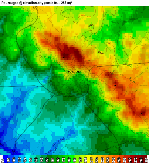
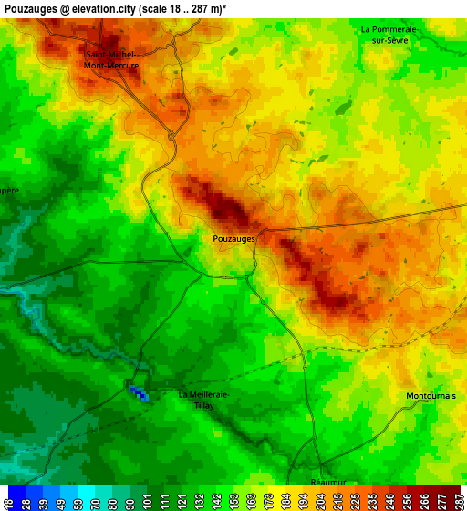
Below is the Elevation map of Pouzauges, which displays elevation range with different colors. Scale of the first map is from 94 to 287 m (308 to 942 ft) with average elevation of 176.9 meters (=580 ft) [note 1]
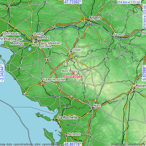
These maps also provides idea of topography and contour of this city, they are displayed at different zoom levels. More info about maps, scale and edge coordinates you can find below images.
| \ | Map #1 | Map #2 | Topo.Map |
| Scale [m] | 94..287 m | 18..287 m | × |
| Scale [ft] | 308..942 ft | 59..942 ft | × |
| Average | 176.9 m = 580 ft | 162.3 m = 532 ft | × |
| Width | 6.69 km = 4.2 mi | 13.38 km = 8.3 mi | 214.2 km = 133.1 mi |
| Height | 6.69 km = 4.2 mi | 13.38 km = 8.3 mi | 214.1 km = 133 mi |
| ↑Max Latitude | 46.809496° | 46.839565° | 47.73382° |
| Latitude at center | 46.77941° | 46.77941° | 46.77941° |
| ↓Min Latitude | 46.749307° | 46.719188° | 45.80778° |
| ← Min Longitude | -0.880135° | -0.924081° | -2.24244° |
| Longitude center | -0.83619° | -0.83619° | -0.83619° |
| →Max Longitude | -0.792245° | -0.748299° | 0.57006° |
Nearby cities:
Cities around Pouzauges sort by population:
• Le Boupère elevation 136 m
7.1 km,  284°
284°
• Les Epesses 189 m
12.5 km,  337°
337°
• Saint-Michel-Mont-Mercure 262 m
6.6 km,  327°
327°
• La Flocellière 212 m
6.2 km, 341°
• Saint-Mesmin 167 m
8 km,  78°
78°
• Montournais 169 m
6.9 km,  127°
127°
• La Meilleraie-Tillay 124 m
4.4 km,  188°
188°
• Saint-Prouant 100 m
9.5 km,  255°
255°
• Mouilleron-en-Pareds 109 m
11.5 km, 185°
• Saint-Amand-sur-Sèvre 161 m
10.5 km,  17°
17°
• Saint-Paul-en-Pareds 117 m
12.6 km,  292°
292°
• La Pommeraie-sur-Sèvre 151 m
7.6 km,  35°
35°
Multilingual:
 En español:
Pouzauges elevación 170 m.
 En France:
Pouzauges élévation 170 m.
 Auf Deutsch:
Pouzauges höhe über dem Meeresspiegel ist 170 m.

Sources and notes:
- [note 1] Map square and city borders are not equal. Map elevation data is calculated only from area inside that square.
- [src 1] Elevation data from geonames database provided with same terms of usage.
- [src 2] The elevation map of Pouzauges is generated using elevation data from NASA's 3 arcsec (90m) resolution SRTM data.
- [src 3] Base (background) map © OpenStreetMap contributors tiles are generated by Geofabrik and OpenTopoMap.
Copyright & License:
This Pouzauges Elevation Map is licensed under CC BY-SA. You may reuse any part from this page, if you give a proper credit by linking to this URL:
 More info on terms of use page.