Saint-André-sur-Vieux-Jonc elevation
Saint-André-sur-Vieux-Jonc (Auvergne-Rhône-Alpes, Département de l'Ain), France elevation is 249 meters and Saint-André-sur-Vieux-Jonc elevation in feet is 817 ft above sea level [src 1]. Saint-André-sur-Vieux-Jonc is a populated place (feature code) with elevation that is 75 meters (246 ft) bigger than average city elevation in France.
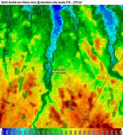
Below is the Elevation map of Saint-André-sur-Vieux-Jonc, which displays elevation range with different colors. Scale of the first map is from 218 to 279 m (715 to 915 ft) with average elevation of 249.8 meters (=820 ft) [note 1]
These maps also provides idea of topography and contour of this city, they are displayed at different zoom levels. More info about maps, scale and edge coordinates you can find below images.
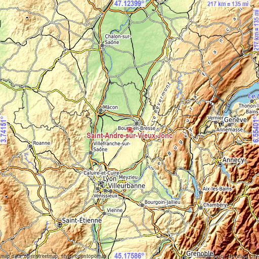
| \ | Map #1 | Topo.Map |
| Scale [m] | 218..279 m | × |
| Scale [ft] | 715..915 ft | × |
| Average | 249.8 m = 820 ft | × |
| Width | 6.77 km = 4.2 mi | 216.6 km = 134.6 mi |
| Height | 6.77 km = 4.2 mi | 216.6 km = 134.6 mi |
| ↑Max Latitude | 46.188981° | 47.12399° |
| Latitude at center | 46.15855° | 46.15855° |
| ↓Min Latitude | 46.128102° | 45.17586° |
| ← Min Longitude | 5.103815° | 3.74151° |
| Longitude center | 5.14776° | 5.14776° |
| →Max Longitude | 5.191705° | 6.55401° |
Nearby cities:
Cities around Saint-André-sur-Vieux-Jonc sort by population:
• Bourg-en-Bresse elevation 231 m
8 km,  48°
48°
• Péronnas 240 m
5.6 km,  60°
60°
• Saint-Denis-lès-Bourg 235 m
5.8 km,  33°
33°
• Polliat 225 m
10.1 km,  350°
350°
• Buellas 222 m
6 km, 348°
• Montagnat 245 m
10.8 km,  84°
84°
• Certines 247 m
9.5 km,  107°
107°
• Neuville-les-Dames 244 m
10.9 km,  272°
272°
• Saint-Paul-de-Varax 263 m
7 km,  191°
191°
• Lent 256 m
5.5 km,  140°
140°
• Servas 268 m
3.1 km,  154°
154°
• Dompierre-sur-Veyle 283 m
10.6 km,  156°
156°
Multilingual:
 En español:
Saint-André-sur-Vieux-Jonc elevación 249 m.
 En France:
Saint-André-sur-Vieux-Jonc élévation 249 m.
 Auf Deutsch:
Saint-André-sur-Vieux-Jonc höhe über dem Meeresspiegel ist 249 m.
 На русском:
Saint-André-sur-Vieux-Jonc высота над уровнем моря 249 м
Sources and notes:
- [note 1] Map square and city borders are not equal. Map elevation data is calculated only from area inside that square.
- [src 1] Elevation data from geonames database provided with same terms of usage.
- [src 2] The elevation map of Saint-André-sur-Vieux-Jonc is generated using elevation data from NASA's 3 arcsec (90m) resolution SRTM data.
- [src 3] Base (background) map © OpenStreetMap contributors tiles are generated by Geofabrik and OpenTopoMap.
Copyright & License:
This Saint-André-sur-Vieux-Jonc Elevation Map is licensed under CC BY-SA. You may reuse any part from this page, if you give a proper credit by linking to this URL:
 More info on terms of use page.