Saint-Avold elevation
Saint-Avold (Grand Est, Moselle), France elevation is 251 meters and Saint-Avold elevation in feet is 823 ft above sea level [src 1]. Saint-Avold is a populated place (feature code) with elevation that is 77 meters (253 ft) bigger than average city elevation in France.
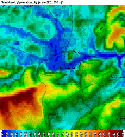
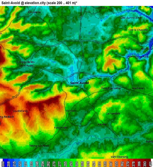
Below is the Elevation map of Saint-Avold, which displays elevation range with different colors. Scale of the first map is from 222 to 396 m (728 to 1299 ft) with average elevation of 280.3 meters (=920 ft) [note 1]
These maps also provides idea of topography and contour of this city, they are displayed at different zoom levels. More info about maps, scale and edge coordinates you can find below images.
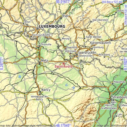
| \ | Map #1 | Map #2 | Topo.Map |
| Scale [m] | 222..396 m | 200..401 m | × |
| Scale [ft] | 728..1299 ft | 656..1316 ft | × |
| Average | 280.3 m = 920 ft | 281.4 m = 923 ft | × |
| Width | 6.4 km = 4 mi | 12.8 km = 8 mi | 204.7 km = 127.2 mi |
| Height | 6.4 km = 4 mi | 12.8 km = 8 mi | 204.7 km = 127.2 mi |
| ↑Max Latitude | 49.133412° | 49.162157° | 50.01677° |
| Latitude at center | 49.10465° | 49.10465° | 49.10465° |
| ↓Min Latitude | 49.075872° | 49.047076° | 48.17545° |
| ← Min Longitude | 6.660075° | 6.616129° | 5.29777° |
| Longitude center | 6.70402° | 6.70402° | 6.70402° |
| →Max Longitude | 6.747965° | 6.791911° | 8.11027° |
Nearby cities:
Cities around Saint-Avold sort by population:
• Freyming-Merlebach elevation 267 m
7.7 km,  48°
48°
• Hombourg-Haut 249 m
5.5 km,  61°
61°
• Folschviller 275 m
3.4 km,  206°
206°
• Longeville-lès-Saint-Avold 247 m
4.6 km,  287°
287°
• Carling 247 m
6.9 km,  7°
7°
• Valmont 280 m
2.3 km,  191°
191°
• Macheren 293 m
5.4 km,  95°
95°
• Ham-sous-Varsberg 224 m
9.4 km,  333°
333°
• Porcelette 259 m
6.8 km, 328°
• Seingbouse 311 m
9.4 km,  84°
84°
• Teting-sur-Nied 259 m
6.1 km, 209°
• Diesen 242 m
8.4 km,  346°
346°
Multilingual:
 En español:
Saint-Avold elevación 251 m.
 En France:
Saint-Avold élévation 251 m.
 Auf Deutsch:
Saint-Avold höhe über dem Meeresspiegel ist 251 m.

Sources and notes:
- [note 1] Map square and city borders are not equal. Map elevation data is calculated only from area inside that square.
- [src 1] Elevation data from geonames database provided with same terms of usage.
- [src 2] The elevation map of Saint-Avold is generated using elevation data from NASA's 3 arcsec (90m) resolution SRTM data.
- [src 3] Base (background) map © OpenStreetMap contributors tiles are generated by Geofabrik and OpenTopoMap.
Copyright & License:
This Saint-Avold Elevation Map is licensed under CC BY-SA. You may reuse any part from this page, if you give a proper credit by linking to this URL:
 More info on terms of use page.