Sainte-Geneviève-sur-Argence elevation
Sainte-Geneviève-sur-Argence (Occitanie, Département de l'Aveyron), France elevation is 805 meters and Sainte-Geneviève-sur-Argence elevation in feet is 2641 ft above sea level [src 1]. Sainte-Geneviève-sur-Argence is a populated place (feature code) with elevation that is 631 meters (2070 ft) bigger than average city elevation in France.
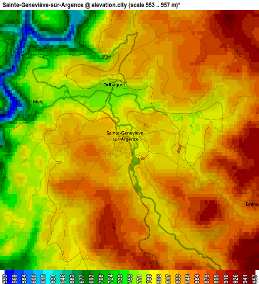
Below is the Elevation map of Sainte-Geneviève-sur-Argence, which displays elevation range with different colors. Scale of the first map is from 553 to 957 m (1814 to 3140 ft) with average elevation of 815.3 meters (=2675 ft) [note 1]
These maps also provides idea of topography and contour of this city, they are displayed at different zoom levels. More info about maps, scale and edge coordinates you can find below images.
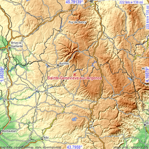
| \ | Map #1 | Topo.Map |
| Scale [m] | 553..957 m | × |
| Scale [ft] | 1814..3140 ft | × |
| Average | 815.3 m = 2675 ft | × |
| Width | 6.93 km = 4.3 mi | 221.9 km = 137.9 mi |
| Height | 6.93 km = 4.3 mi | 221.9 km = 137.9 mi |
| ↑Max Latitude | 44.833393° | 45.79139° |
| Latitude at center | 44.80222° | 44.80222° |
| ↓Min Latitude | 44.77103° | 43.7958° |
| ← Min Longitude | 2.715595° | 1.35329° |
| Longitude center | 2.75954° | 2.75954° |
| →Max Longitude | 2.803485° | 4.16579° |
Nearby cities:
Cities around Sainte-Geneviève-sur-Argence sort by population:
• Aurillac elevation 625 m
28.7 km,  298°
298°
• Arpajon-sur-Cère 613 m
26.4 km, 295°
• Espalion 340 m
31.1 km,  179°
179°
• Vic-sur-Cère 670 m
22.4 km,  331°
331°
• Naucelles 740 m
32 km, 302°
• Entraygues-sur-Truyère 258 m
23.1 km,  221°
221°
• Laguiole 1008 m
14.8 km,  152°
152°
• Polminhac 664 m
22 km,  319°
319°
• Saint-Simon 721 m
27.8 km,  310°
310°
• Neuvéglise 932 m
22.5 km,  51°
51°
• Pierrefort 940 m
14.7 km,  24°
24°
• Chaudes-Aigues 837 m
20.1 km,  73°
73°
Multilingual:
 En español:
Sainte-Geneviève-sur-Argence elevación 805 m.
 En France:
Sainte-Geneviève-sur-Argence élévation 805 m.
 Auf Deutsch:
Sainte-Geneviève-sur-Argence höhe über dem Meeresspiegel ist 805 m.
 На русском:
Сент-Женевьев-сюр-Аржанс высота над уровнем моря 805 м
Sources and notes:
- [note 1] Map square and city borders are not equal. Map elevation data is calculated only from area inside that square.
- [src 1] Elevation data from geonames database provided with same terms of usage.
- [src 2] The elevation map of Sainte-Geneviève-sur-Argence is generated using elevation data from NASA's 3 arcsec (90m) resolution SRTM data.
- [src 3] Base (background) map © OpenStreetMap contributors tiles are generated by Geofabrik and OpenTopoMap.
Copyright & License:
This Sainte-Geneviève-sur-Argence Elevation Map is licensed under CC BY-SA. You may reuse any part from this page, if you give a proper credit by linking to this URL:
 More info on terms of use page.