Espalion elevation
Espalion (Occitanie, Département de l'Aveyron), France elevation is 340 meters and Espalion elevation in feet is 1115 ft above sea level [src 1]. Espalion is a populated place (feature code) with elevation that is 166 meters (545 ft) bigger than average city elevation in France.
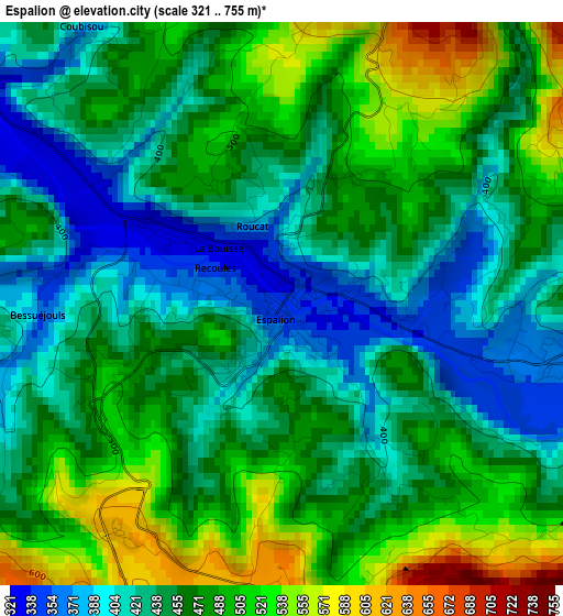
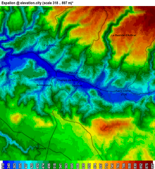
Below is the Elevation map of Espalion, which displays elevation range with different colors. Scale of the first map is from 321 to 755 m (1053 to 2477 ft) with average elevation of 460.3 meters (=1510 ft) [note 1]
These maps also provides idea of topography and contour of this city, they are displayed at different zoom levels. More info about maps, scale and edge coordinates you can find below images.
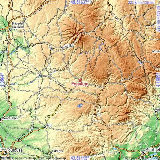
| \ | Map #1 | Map #2 | Topo.Map |
| Scale [m] | 321..755 m | 318..897 m | × |
| Scale [ft] | 1053..2477 ft | 1043..2943 ft | × |
| Average | 460.3 m = 1510 ft | 547.2 m = 1795 ft | × |
| Width | 6.97 km = 4.3 mi | 13.94 km = 8.7 mi | 223 km = 138.6 mi |
| Height | 6.97 km = 4.3 mi | 13.94 km = 8.7 mi | 223 km = 138.6 mi |
| ↑Max Latitude | 44.553694° | 44.585° | 45.51637° |
| Latitude at center | 44.52237° | 44.52237° | 44.52237° |
| ↓Min Latitude | 44.49103° | 44.459672° | 43.51112° |
| ← Min Longitude | 2.718705° | 2.674759° | 1.3564° |
| Longitude center | 2.76265° | 2.76265° | 2.76265° |
| →Max Longitude | 2.806595° | 2.850541° | 4.1689° |
Nearby cities:
Cities around Espalion sort by population:
• Rodez elevation 627 m
24.1 km,  218°
218°
• Sébazac-Concourès 608 m
18.2 km, 224°
• Bozouls 553 m
6.5 km,  207°
207°
• Saint-Geniez-d’Olt 431 m
17.8 km,  110°
110°
• Salles-la-Source 397 m
22.1 km,  243°
243°
• Le Monastère 532 m
24.8 km, 215°
• Marcillac-Vallon 283 m
24.2 km,  257°
257°
• Laissac 596 m
16.4 km,  163°
163°
• Sainte-Radegonde 667 m
23.2 km, 207°
• Entraygues-sur-Truyère 258 m
20.7 km,  311°
311°
• Laguiole 1008 m
19.2 km,  20°
20°
• La Loubière 559 m
18.4 km,  204°
204°
Multilingual:
 En español:
Espalion elevación 340 m.
 En France:
Espalion élévation 340 m.
 Auf Deutsch:
Espalion höhe über dem Meeresspiegel ist 340 m.

Sources and notes:
- [note 1] Map square and city borders are not equal. Map elevation data is calculated only from area inside that square.
- [src 1] Elevation data from geonames database provided with same terms of usage.
- [src 2] The elevation map of Espalion is generated using elevation data from NASA's 3 arcsec (90m) resolution SRTM data.
- [src 3] Base (background) map © OpenStreetMap contributors tiles are generated by Geofabrik and OpenTopoMap.
Copyright & License:
This Espalion Elevation Map is licensed under CC BY-SA. You may reuse any part from this page, if you give a proper credit by linking to this URL:
 More info on terms of use page.