Rodez elevation
Rodez (Occitanie, Département de l'Aveyron), France elevation is 627 meters and Rodez elevation in feet is 2057 ft above sea level [src 1]. Rodez is a seat of a second-order administrative division (feature code) with elevation that is 453 meters (1486 ft) bigger than average city elevation in France.
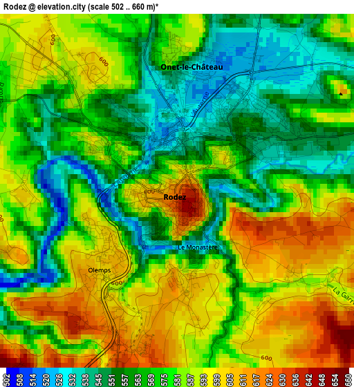
Below is the Elevation map of Rodez, which displays elevation range with different colors. Scale of the first map is from 502 to 660 m (1647 to 2165 ft) with average elevation of 576.9 meters (=1893 ft) [note 1]
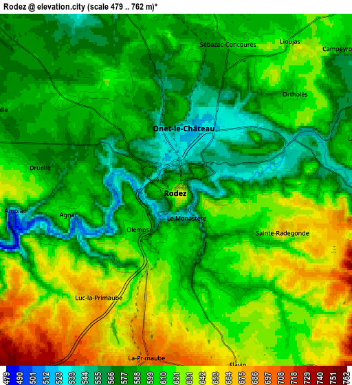
These maps also provides idea of topography and contour of this city, they are displayed at different zoom levels. More info about maps, scale and edge coordinates you can find below images.
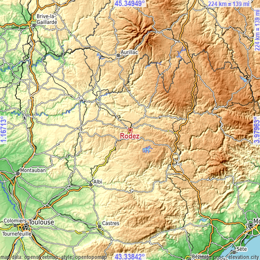
| \ | Map #1 | Map #2 | Topo.Map |
| Scale [m] | 502..660 m | 479..762 m | × |
| Scale [ft] | 1647..2165 ft | 1572..2500 ft | × |
| Average | 576.9 m = 1893 ft | 605.4 m = 1986 ft | × |
| Width | 6.99 km = 4.3 mi | 13.98 km = 8.7 mi | 223.6 km = 138.9 mi |
| Height | 6.99 km = 4.3 mi | 13.98 km = 8.7 mi | 223.6 km = 138.9 mi |
| ↑Max Latitude | 44.383995° | 44.415393° | 45.34949° |
| Latitude at center | 44.35258° | 44.35258° | 44.35258° |
| ↓Min Latitude | 44.321148° | 44.2897° | 43.33842° |
| ← Min Longitude | 2.529435° | 2.485489° | 1.16713° |
| Longitude center | 2.57338° | 2.57338° | 2.57338° |
| →Max Longitude | 2.617325° | 2.661271° | 3.97963° |
Nearby cities:
Cities around Rodez sort by population:
• Luc-la-Primaube elevation 681 m
5.2 km,  215°
215°
• Olemps 600 m
1.9 km,  248°
248°
• Sébazac-Concourès 608 m
6.3 km,  22°
22°
• Baraqueville 793 m
14.1 km,  233°
233°
• Flavin 648 m
7.5 km,  160°
160°
• Salles-la-Source 397 m
10.4 km,  332°
332°
• Le Monastère 532 m
1.3 km, 157°
• Calmont 574 m
12.5 km,  202°
202°
• Druelle 597 m
5.5 km,  278°
278°
• Sainte-Radegonde 667 m
4.6 km,  111°
111°
• La Loubière 559 m
7.8 km,  74°
74°
• Moyrazès 726 m
10.7 km,  263°
263°
Multilingual:
 En español:
Rodez elevación 627 m.
 En France:
Rodez élévation 627 m.


Sources and notes:
- [note 1] Map square and city borders are not equal. Map elevation data is calculated only from area inside that square.
- [src 1] Elevation data from geonames database provided with same terms of usage.
- [src 2] The elevation map of Rodez is generated using elevation data from NASA's 3 arcsec (90m) resolution SRTM data.
- [src 3] Base (background) map © OpenStreetMap contributors tiles are generated by Geofabrik and OpenTopoMap.
Copyright & License:
This Rodez Elevation Map is licensed under CC BY-SA. You may reuse any part from this page, if you give a proper credit by linking to this URL:
 More info on terms of use page.