Arpajon-sur-Cère elevation
Arpajon-sur-Cère (Auvergne-Rhône-Alpes, Cantal), France elevation is 613 meters and Arpajon-sur-Cère elevation in feet is 2011 ft above sea level [src 1]. Arpajon-sur-Cère is a populated place (feature code) with elevation that is 439 meters (1440 ft) bigger than average city elevation in France.
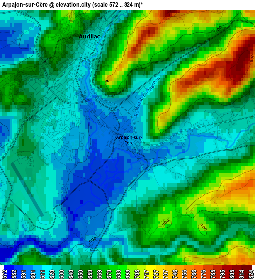
Below is the Elevation map of Arpajon-sur-Cère, which displays elevation range with different colors. Scale of the first map is from 572 to 824 m (1877 to 2703 ft) with average elevation of 649.4 meters (=2131 ft) [note 1]
These maps also provides idea of topography and contour of this city, they are displayed at different zoom levels. More info about maps, scale and edge coordinates you can find below images.
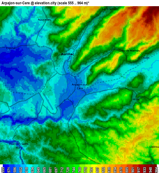
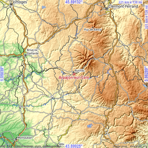
| \ | Map #1 | Map #2 | Topo.Map |
| Scale [m] | 572..824 m | 555..964 m | × |
| Scale [ft] | 1877..2703 ft | 1821..3163 ft | × |
| Average | 649.4 m = 2131 ft | 687.6 m = 2256 ft | × |
| Width | 6.92 km = 4.3 mi | 13.84 km = 8.6 mi | 221.5 km = 137.6 mi |
| Height | 6.92 km = 4.3 mi | 13.84 km = 8.6 mi | 221.5 km = 137.6 mi |
| ↑Max Latitude | 44.935028° | 44.966128° | 45.89132° |
| Latitude at center | 44.90391° | 44.90391° | 44.90391° |
| ↓Min Latitude | 44.872775° | 44.841624° | 43.89925° |
| ← Min Longitude | 2.412695° | 2.368749° | 1.05039° |
| Longitude center | 2.45664° | 2.45664° | 2.45664° |
| →Max Longitude | 2.500585° | 2.544531° | 3.86289° |
Nearby cities:
Cities around Arpajon-sur-Cère sort by population:
• Aurillac elevation 625 m
2.7 km,  331°
331°
• Ytrac 579 m
7.5 km,  276°
276°
• Vic-sur-Cère 670 m
15.7 km,  57°
57°
• Jussac 678 m
9.7 km,  344°
344°
• Naucelles 740 m
6.8 km, 334°
• Saint-Mamet-la-Salvetat 733 m
12.9 km,  246°
246°
• Polminhac 664 m
10.9 km, 60°
• Saint-Cernin 660 m
17.4 km,  350°
350°
• Saint-Paul-des-Landes 552 m
12 km,  291°
291°
• Sansac-de-Marmiesse 619 m
8.9 km,  255°
255°
• Laroquebrou 488 m
22.1 km, 289°
• Saint-Simon 721 m
7.1 km,  21°
21°
Multilingual:
 En español:
Arpajon-sur-Cère elevación 613 m.
 En France:
Arpajon-sur-Cère élévation 613 m.
 Auf Deutsch:
Arpajon-sur-Cère höhe über dem Meeresspiegel ist 613 m.

Sources and notes:
- [note 1] Map square and city borders are not equal. Map elevation data is calculated only from area inside that square.
- [src 1] Elevation data from geonames database provided with same terms of usage.
- [src 2] The elevation map of Arpajon-sur-Cère is generated using elevation data from NASA's 3 arcsec (90m) resolution SRTM data.
- [src 3] Base (background) map © OpenStreetMap contributors tiles are generated by Geofabrik and OpenTopoMap.
Copyright & License:
This Arpajon-sur-Cère Elevation Map is licensed under CC BY-SA. You may reuse any part from this page, if you give a proper credit by linking to this URL:
 More info on terms of use page.