Saint-Fargeau-Ponthierry elevation
Saint-Fargeau-Ponthierry (Île-de-France, Seine-et-Marne), France elevation is 84 meters and Saint-Fargeau-Ponthierry elevation in feet is 276 ft above sea level [src 1]. Saint-Fargeau-Ponthierry is a populated place (feature code) with elevation that is 90 meters (295 ft) smaller than average city elevation in France.
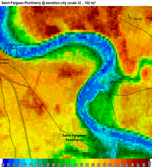
Below is the Elevation map of Saint-Fargeau-Ponthierry, which displays elevation range with different colors. Scale of the first map is from 32 to 102 m (105 to 335 ft) with average elevation of 70.7 meters (=232 ft) [note 1]
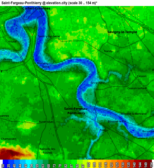
These maps also provides idea of topography and contour of this city, they are displayed at different zoom levels. More info about maps, scale and edge coordinates you can find below images.
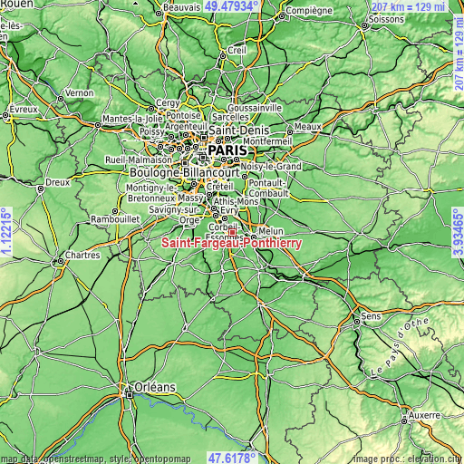
| \ | Map #1 | Map #2 | Topo.Map |
| Scale [m] | 32..102 m | 30..154 m | × |
| Scale [ft] | 105..335 ft | 98..505 ft | × |
| Average | 70.7 m = 232 ft | 76.3 m = 250 ft | × |
| Width | 6.47 km = 4 mi | 12.94 km = 8 mi | 207 km = 128.6 mi |
| Height | 6.47 km = 4 mi | 12.94 km = 8 mi | 207 km = 128.6 mi |
| ↑Max Latitude | 48.586208° | 48.615269° | 49.47934° |
| Latitude at center | 48.55713° | 48.55713° | 48.55713° |
| ↓Min Latitude | 48.528035° | 48.498924° | 47.6178° |
| ← Min Longitude | 2.484455° | 2.440509° | 1.12215° |
| Longitude center | 2.5284° | 2.5284° | 2.5284° |
| →Max Longitude | 2.572345° | 2.616291° | 3.93465° |
Nearby cities:
Cities around Saint-Fargeau-Ponthierry sort by population:
• Corbeil-Essonnes elevation 36 m
6.2 km,  331°
331°
• Savigny-le-Temple 75 m
4.4 km,  64°
64°
• Mennecy 82 m
6.4 km,  282°
282°
• Ponthierry 45 m
2.9 km,  155°
155°
• Cesson 82 m
5.9 km,  84°
84°
• Nandy 82 m
3.8 km,  41°
41°
• Saintry-sur-Seine 60 m
5 km, 330°
• Boissise-le-Roi 68 m
4.7 km,  139°
139°
• Le Coudray-Montceaux 71 m
2.2 km,  289°
289°
• Pringy 74 m
5 km,  149°
149°
• Seine-Port 54 m
1.8 km,  88°
88°
• Ormoy 54 m
6 km, 289°
Multilingual:
 En español:
Saint-Fargeau-Ponthierry elevación 84 m.
 En France:
Saint-Fargeau-Ponthierry élévation 84 m.
 Auf Deutsch:
Saint-Fargeau-Ponthierry höhe über dem Meeresspiegel ist 84 m.
 На русском:
Saint-Fargeau-Ponthierry высота над уровнем моря 84 м
Sources and notes:
- [note 1] Map square and city borders are not equal. Map elevation data is calculated only from area inside that square.
- [src 1] Elevation data from geonames database provided with same terms of usage.
- [src 2] The elevation map of Saint-Fargeau-Ponthierry is generated using elevation data from NASA's 3 arcsec (90m) resolution SRTM data.
- [src 3] Base (background) map © OpenStreetMap contributors tiles are generated by Geofabrik and OpenTopoMap.
Copyright & License:
This Saint-Fargeau-Ponthierry Elevation Map is licensed under CC BY-SA. You may reuse any part from this page, if you give a proper credit by linking to this URL:
 More info on terms of use page.