Saint-Hippolyte-du-Fort elevation
Saint-Hippolyte-du-Fort (Occitanie, Gard), France elevation is 168 meters and Saint-Hippolyte-du-Fort elevation in feet is 551 ft above sea level [src 1]. Saint-Hippolyte-du-Fort is a populated place (feature code) with elevation that is 6 meters (20 ft) smaller than average city elevation in France.
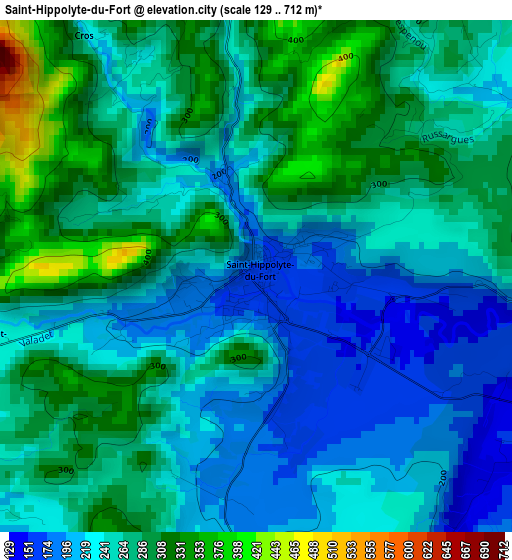
Below is the Elevation map of Saint-Hippolyte-du-Fort, which displays elevation range with different colors. Scale of the first map is from 129 to 712 m (423 to 2336 ft) with average elevation of 255.6 meters (=839 ft) [note 1]
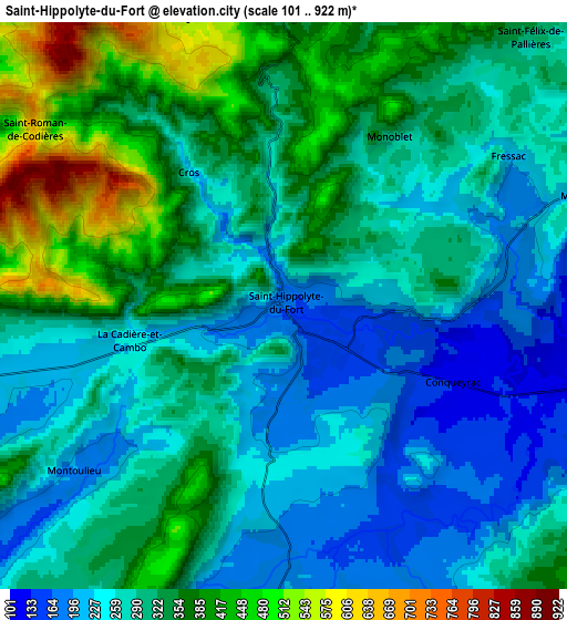
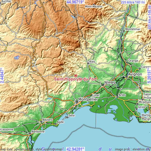
These maps also provides idea of topography and contour of this city, they are displayed at different zoom levels. More info about maps, scale and edge coordinates you can find below images.
| \ | Map #1 | Map #2 | Topo.Map |
| Scale [m] | 129..712 m | 101..922 m | × |
| Scale [ft] | 423..2336 ft | 331..3025 ft | × |
| Average | 255.6 m = 839 ft | 306.3 m = 1005 ft | × |
| Width | 7.03 km = 4.4 mi | 14.07 km = 8.7 mi | 225.1 km = 139.9 mi |
| Height | 7.03 km = 4.4 mi | 14.07 km = 8.7 mi | 225.1 km = 139.9 mi |
| ↑Max Latitude | 43.995243° | 44.026848° | 44.96719° |
| Latitude at center | 43.96362° | 43.96362° | 43.96362° |
| ↓Min Latitude | 43.931981° | 43.900324° | 42.94281° |
| ← Min Longitude | 3.811775° | 3.767829° | 2.44947° |
| Longitude center | 3.85572° | 3.85572° | 3.85572° |
| →Max Longitude | 3.899665° | 3.943611° | 5.26197° |
Nearby cities:
Cities around Saint-Hippolyte-du-Fort sort by population:
• Ganges elevation 165 m
12.3 km,  254°
254°
• Anduze 140 m
14.5 km,  45°
45°
• Saint-Jean-du-Gard 192 m
15.9 km,  8°
8°
• Quissac 86 m
12.8 km,  115°
115°
• Boisset-et-Gaujac 167 m
15.4 km, 52°
• Sauve 107 m
7.9 km,  108°
108°
• Sumène 201 m
11.4 km,  279°
279°
• Claret 169 m
11.9 km,  160°
160°
• Saint-Bauzille-de-Putois 139 m
12.3 km,  231°
231°
• Laroque 148 m
11.5 km, 246°
• Cazilhac 165 m
13.2 km, 248°
• Lasalle 284 m
9.1 km,  359°
359°
Multilingual:
 En español:
Saint-Hippolyte-du-Fort elevación 168 m.
 En France:
Saint-Hippolyte-du-Fort élévation 168 m.
 Auf Deutsch:
Saint-Hippolyte-du-Fort höhe über dem Meeresspiegel ist 168 m.
 На русском:
Saint-Hippolyte-du-Fort высота над уровнем моря 168 м
Sources and notes:
- [note 1] Map square and city borders are not equal. Map elevation data is calculated only from area inside that square.
- [src 1] Elevation data from geonames database provided with same terms of usage.
- [src 2] The elevation map of Saint-Hippolyte-du-Fort is generated using elevation data from NASA's 3 arcsec (90m) resolution SRTM data.
- [src 3] Base (background) map © OpenStreetMap contributors tiles are generated by Geofabrik and OpenTopoMap.
Copyright & License:
This Saint-Hippolyte-du-Fort Elevation Map is licensed under CC BY-SA. You may reuse any part from this page, if you give a proper credit by linking to this URL:
 More info on terms of use page.