Saint-Jean-Pied-de-Port elevation
Saint-Jean-Pied-de-Port (Nouvelle-Aquitaine, Département des Pyrénées-Atlantiques), France elevation is 170 meters and Saint-Jean-Pied-de-Port elevation in feet is 558 ft above sea level [src 1]. Saint-Jean-Pied-de-Port is a populated place (feature code) with elevation that is 4 meters (13 ft) smaller than average city elevation in France.
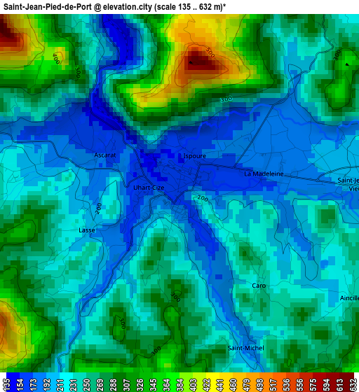
Below is the Elevation map of Saint-Jean-Pied-de-Port, which displays elevation range with different colors. Scale of the first map is from 135 to 632 m (443 to 2073 ft) with average elevation of 251.3 meters (=824 ft) [note 1]
These maps also provides idea of topography and contour of this city, they are displayed at different zoom levels. More info about maps, scale and edge coordinates you can find below images.
| \ | Map #1 | Topo.Map |
| Scale [m] | 135..632 m | × |
| Scale [ft] | 443..2073 ft | × |
| Average | 251.3 m = 824 ft | × |
| Width | 7.13 km = 4.4 mi | 228.1 km = 141.7 mi |
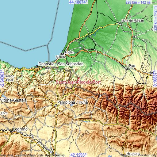
| Height | 7.13 km = 4.4 mi | 228.1 km = 141.7 mi |
| ↑Max Latitude | 43.195675° | 44.18074° |
| Latitude at center | 43.16363° | 43.16363° |
| ↓Min Latitude | 43.131568° | 42.1293° |
| ← Min Longitude | -1.281325° | -2.64363° |
| Longitude center | -1.23738° | -1.23738° |
| →Max Longitude | -1.193435° | 0.16887° |
Nearby cities:
Cities around Saint-Jean-Pied-de-Port sort by population:
• Hasparren elevation 88 m
25.1 km,  347°
347°
• Ustaritz 19 m
31.4 km,  325°
325°
• Cambo-les-Bains 70 m
25.4 km, 328°
• Mauléon-Licharre 135 m
29.8 km,  76°
76°
• Sare 81 m
32.3 km,  300°
300°
• Saint-Palais 51 m
24.7 km,  42°
42°
• Espelette 77 m
26 km,  319°
319°
• Itxassou 76 m
22.9 km, 323°
• Saint-Étienne-de-Baïgorry 164 m
9 km,  278°
278°
• Larressore 72 m
28 km, 324°
• Chéraute 139 m
30.8 km, 75°
• Souraïde 71 m
27.6 km, 315°
Multilingual:
 En español:
Saint-Jean-Pied-de-Port, San Juan Pie de Puerto elevación 170 m.
 En France:
Saint-Jean-Pied-de-Port élévation 170 m.
 Auf Deutsch:
Saint-Jean-Pied-de-Port höhe über dem Meeresspiegel ist 170 m.
 На русском:
Сен-Жан-Пье-де-Пор высота над уровнем моря 170 м
Sources and notes:
- [note 1] Map square and city borders are not equal. Map elevation data is calculated only from area inside that square.
- [src 1] Elevation data from geonames database provided with same terms of usage.
- [src 2] The elevation map of Saint-Jean-Pied-de-Port is generated using elevation data from NASA's 3 arcsec (90m) resolution SRTM data.
- [src 3] Base (background) map © OpenStreetMap contributors tiles are generated by Geofabrik and OpenTopoMap.
Copyright & License:
This Saint-Jean-Pied-de-Port Elevation Map is licensed under CC BY-SA. You may reuse any part from this page, if you give a proper credit by linking to this URL:
 More info on terms of use page.