Saint-Palais elevation
Saint-Palais (Nouvelle-Aquitaine, Département des Pyrénées-Atlantiques), France elevation is 51 meters and Saint-Palais elevation in feet is 167 ft above sea level [src 1]. Saint-Palais is a populated place (feature code) with elevation that is 123 meters (404 ft) smaller than average city elevation in France.
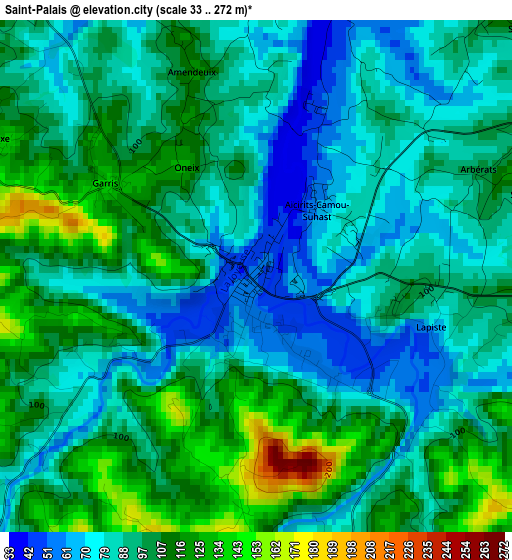
Below is the Elevation map of Saint-Palais, which displays elevation range with different colors. Scale of the first map is from 33 to 272 m (108 to 892 ft) with average elevation of 95.1 meters (=312 ft) [note 1]
These maps also provides idea of topography and contour of this city, they are displayed at different zoom levels. More info about maps, scale and edge coordinates you can find below images.
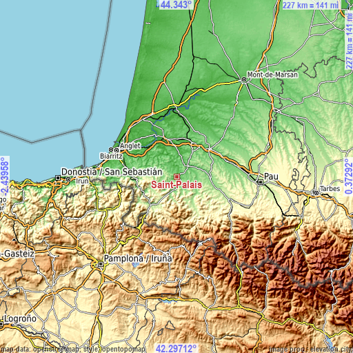
| \ | Map #1 | Topo.Map |
| Scale [m] | 33..272 m | × |
| Scale [ft] | 108..892 ft | × |
| Average | 95.1 m = 312 ft | × |
| Width | 7.11 km = 4.4 mi | 227.5 km = 141.4 mi |
| Height | 7.11 km = 4.4 mi | 227.5 km = 141.4 mi |
| ↑Max Latitude | 43.360629° | 44.343° |
| Latitude at center | 43.32867° | 43.32867° |
| ↓Min Latitude | 43.296694° | 42.29712° |
| ← Min Longitude | -1.077275° | -2.43958° |
| Longitude center | -1.03333° | -1.03333° |
| →Max Longitude | -0.989385° | 0.37292° |
Nearby cities:
Cities around Saint-Palais sort by population:
• Hasparren elevation 88 m
22.8 km,  285°
285°
• Salies-de-Béarn 70 m
18.4 km,  28°
28°
• Peyrehorade 9 m
25.4 km,  344°
344°
• Mauléon-Licharre 135 m
16.8 km,  132°
132°
• Saint-Jean-Pied-de-Port 170 m
24.7 km,  222°
222°
• Sauveterre-de-Béarn 89 m
11.3 km,  45°
45°
• Bardos 120 m
21.2 km,  319°
319°
• Chéraute 139 m
17.2 km, 129°
• Navarrenx 129 m
22.2 km,  92°
92°
• Labatut 48 m
24.9 km,  9°
9°
• Bidache 36 m
19.2 km,  333°
333°
• Puyoô 40 m
23.9 km,  24°
24°
Multilingual:
 En español:
Donapaleu elevación 51 m.
 En France:
Saint-Palais élévation 51 m.
 Auf Deutsch:
Saint-Palais höhe über dem Meeresspiegel ist 51 m.

Sources and notes:
- [note 1] Map square and city borders are not equal. Map elevation data is calculated only from area inside that square.
- [src 1] Elevation data from geonames database provided with same terms of usage.
- [src 2] The elevation map of Saint-Palais is generated using elevation data from NASA's 3 arcsec (90m) resolution SRTM data.
- [src 3] Base (background) map © OpenStreetMap contributors tiles are generated by Geofabrik and OpenTopoMap.
Copyright & License:
This Saint-Palais Elevation Map is licensed under CC BY-SA. You may reuse any part from this page, if you give a proper credit by linking to this URL:
 More info on terms of use page.