Puyoô elevation
Puyoô (Nouvelle-Aquitaine, Département des Pyrénées-Atlantiques), France elevation is 40 meters and Puyoô elevation in feet is 131 ft above sea level [src 1]. Puyoô is a populated place (feature code) with elevation that is 134 meters (440 ft) smaller than average city elevation in France.
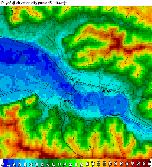
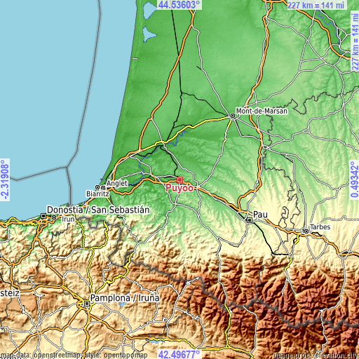
Below is the Elevation map of Puyoô, which displays elevation range with different colors. Scale of the first map is from 15 to 164 m (49 to 538 ft) with average elevation of 71.2 meters (=234 ft) [note 1]
These maps also provides idea of topography and contour of this city, they are displayed at different zoom levels. More info about maps, scale and edge coordinates you can find below images.
| \ | Map #1 | Topo.Map |
| Scale [m] | 15..164 m | × |
| Scale [ft] | 49..538 ft | × |
| Average | 71.2 m = 234 ft | × |
| Width | 7.09 km = 4.4 mi | 226.7 km = 140.9 mi |
| Height | 7.09 km = 4.4 mi | 226.7 km = 140.9 mi |
| ↑Max Latitude | 43.556875° | 44.53603° |
| Latitude at center | 43.52502° | 43.52502° |
| ↓Min Latitude | 43.493148° | 42.49677° |
| ← Min Longitude | -0.956775° | -2.31908° |
| Longitude center | -0.91283° | -0.91283° |
| →Max Longitude | -0.868885° | 0.49342° |
Nearby cities:
Cities around Puyoô sort by population:
• Orthez elevation 78 m
12 km,  109°
109°
• Salies-de-Béarn 70 m
5.7 km,  189°
189°
• Peyrehorade 9 m
16.6 km,  279°
279°
• Pouillon 48 m
11.3 km,  321°
321°
• Amou 52 m
15.3 km,  60°
60°
• Pomarez 50 m
13.4 km,  30°
30°
• Sauveterre-de-Béarn 89 m
14 km, 186°
• Habas 110 m
5.4 km,  345°
345°
• Saugnac-et-Cambran 14 m
17.5 km,  337°
337°
• Heugas 52 m
18.9 km,  314°
314°
• Labatut 48 m
6.3 km,  296°
296°
• Mimbaste 17 m
14.6 km, 340°
Multilingual:
 En español:
Puyoô elevación 40 m.
 En France:
Puyoô élévation 40 m.


Sources and notes:
- [note 1] Map square and city borders are not equal. Map elevation data is calculated only from area inside that square.
- [src 1] Elevation data from geonames database provided with same terms of usage.
- [src 2] The elevation map of Puyoô is generated using elevation data from NASA's 3 arcsec (90m) resolution SRTM data.
- [src 3] Base (background) map © OpenStreetMap contributors tiles are generated by Geofabrik and OpenTopoMap.
Copyright & License:
This Puyoô Elevation Map is licensed under CC BY-SA. You may reuse any part from this page, if you give a proper credit by linking to this URL:
 More info on terms of use page.