Saint-Maximin-la-Sainte-Baume elevation
Saint-Maximin-la-Sainte-Baume (Provence-Alpes-Côte d'Azur, Var), France elevation is 313 meters and Saint-Maximin-la-Sainte-Baume elevation in feet is 1027 ft above sea level [src 1]. Saint-Maximin-la-Sainte-Baume is a populated place (feature code) with elevation that is 139 meters (456 ft) bigger than average city elevation in France.
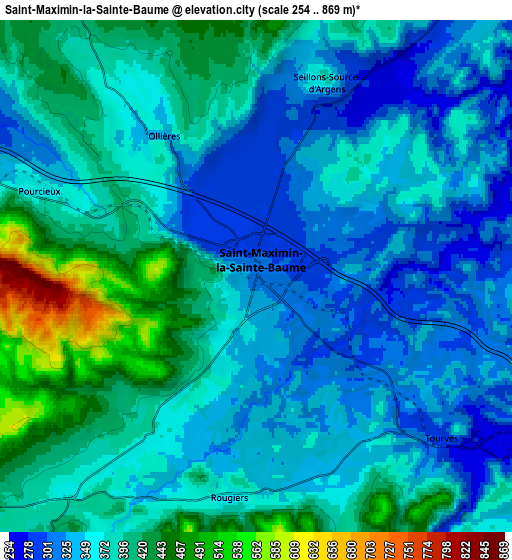
Below is the Elevation map of Saint-Maximin-la-Sainte-Baume, which displays elevation range with different colors. Scale of the first map is from 276 to 612 m (906 to 2008 ft) with average elevation of 347.9 meters (=1141 ft) [note 1]
These maps also provides idea of topography and contour of this city, they are displayed at different zoom levels. More info about maps, scale and edge coordinates you can find below images.

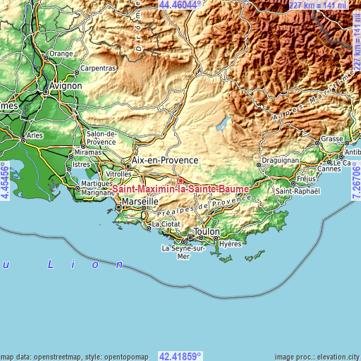
| \ | Map #1 | Map #2 | Topo.Map |
| Scale [m] | 276..612 m | 254..869 m | × |
| Scale [ft] | 906..2008 ft | 833..2851 ft | × |
| Average | 347.9 m = 1141 ft | 371.1 m = 1218 ft | × |
| Width | 7.09 km = 4.4 mi | 14.19 km = 8.8 mi | 227 km = 141.1 mi |
| Height | 7.09 km = 4.4 mi | 14.19 km = 8.8 mi | 227 km = 141.1 mi |
| ↑Max Latitude | 43.480026° | 43.511905° | 44.46044° |
| Latitude at center | 43.44813° | 43.44813° | 43.44813° |
| ↓Min Latitude | 43.416217° | 43.384288° | 42.41859° |
| ← Min Longitude | 5.816865° | 5.772919° | 4.45456° |
| Longitude center | 5.86081° | 5.86081° | 5.86081° |
| →Max Longitude | 5.904755° | 5.948701° | 7.26706° |
Nearby cities:
Cities around Saint-Maximin-la-Sainte-Baume sort by population:
• Brignoles elevation 229 m
16.9 km,  106°
106°
• Trets 247 m
14.3 km,  270°
270°
• Saint-Zacharie 278 m
14.2 km,  240°
240°
• Pourrières 304 m
12.1 km,  302°
302°
• Le Val 243 m
17.2 km,  93°
93°
• Tourves 291 m
6.8 km,  131°
131°
• Nans-les-Pins 398 m
10.7 km,  216°
216°
• Barjols 265 m
17 km,  44°
44°
• La Roquebrussanne 370 m
15.2 km,  142°
142°
• Bras 297 m
8 km,  71°
71°
• La Celle 237 m
15.4 km, 112°
• Rougiers 364 m
6.3 km,  187°
187°
Multilingual:
 En español:
Saint-Maximin-la-Sainte-Baume elevación 313 m.
 En France:
Saint-Maximin-la-Sainte-Baume élévation 313 m.
 Auf Deutsch:
Saint-Maximin-la-Sainte-Baume höhe über dem Meeresspiegel ist 313 m.
 На русском:
Сен-Максимен-ла-Сент-Бом высота над уровнем моря 313 м
Sources and notes:
- [note 1] Map square and city borders are not equal. Map elevation data is calculated only from area inside that square.
- [src 1] Elevation data from geonames database provided with same terms of usage.
- [src 2] The elevation map of Saint-Maximin-la-Sainte-Baume is generated using elevation data from NASA's 3 arcsec (90m) resolution SRTM data.
- [src 3] Base (background) map © OpenStreetMap contributors tiles are generated by Geofabrik and OpenTopoMap.
Copyright & License:
This Saint-Maximin-la-Sainte-Baume Elevation Map is licensed under CC BY-SA. You may reuse any part from this page, if you give a proper credit by linking to this URL:
 More info on terms of use page.