Le Val elevation
Le Val (Provence-Alpes-Côte d'Azur, Var), France elevation is 243 meters and Le Val elevation in feet is 797 ft above sea level [src 1]. Le Val is a populated place (feature code) with elevation that is 69 meters (226 ft) bigger than average city elevation in France.
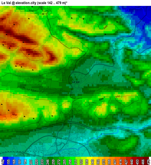
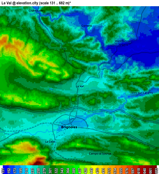
Below is the Elevation map of Le Val, which displays elevation range with different colors. Scale of the first map is from 142 to 479 m (466 to 1572 ft) with average elevation of 277.9 meters (=912 ft) [note 1]
These maps also provides idea of topography and contour of this city, they are displayed at different zoom levels. More info about maps, scale and edge coordinates you can find below images.
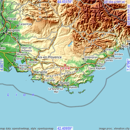
| \ | Map #1 | Map #2 | Topo.Map |
| Scale [m] | 142..479 m | 131..682 m | × |
| Scale [ft] | 466..1572 ft | 430..2238 ft | × |
| Average | 277.9 m = 912 ft | 282.9 m = 928 ft | × |
| Width | 7.1 km = 4.4 mi | 14.19 km = 8.8 mi | 227.1 km = 141.1 mi |
| Height | 7.1 km = 4.4 mi | 14.19 km = 8.8 mi | 227.1 km = 141.1 mi |
| ↑Max Latitude | 43.47118° | 43.503064° | 44.45174° |
| Latitude at center | 43.43928° | 43.43928° | 43.43928° |
| ↓Min Latitude | 43.407363° | 43.375429° | 42.40959° |
| ← Min Longitude | 6.029405° | 5.985459° | 4.6671° |
| Longitude center | 6.07335° | 6.07335° | 6.07335° |
| →Max Longitude | 6.117295° | 6.161241° | 7.4796° |
Nearby cities:
Cities around Le Val sort by population:
• Brignoles elevation 229 m
3.8 km,  194°
194°
• Garéoult 311 m
12.5 km, 190°
• Tourves 291 m
12.6 km,  253°
253°
• Carcès 152 m
9.7 km,  65°
65°
• Cotignac 239 m
11.7 km,  31°
31°
• Besse-sur-Issole 250 m
13.1 km,  140°
140°
• Bras 297 m
10.2 km,  290°
290°
• Forcalqueiret 308 m
11.5 km,  175°
175°
• Sainte-Anastasie-sur-Issole 299 m
11.5 km,  158°
158°
• Cabasse 199 m
11.9 km,  96°
96°
• Camps-la-Source 293 m
6.2 km, 162°
• La Celle 237 m
5.7 km,  210°
210°
Multilingual:
 En español:
Le Val elevación 243 m.
 En France:
Le Val élévation 243 m.


Sources and notes:
- [note 1] Map square and city borders are not equal. Map elevation data is calculated only from area inside that square.
- [src 1] Elevation data from geonames database provided with same terms of usage.
- [src 2] The elevation map of Le Val is generated using elevation data from NASA's 3 arcsec (90m) resolution SRTM data.
- [src 3] Base (background) map © OpenStreetMap contributors tiles are generated by Geofabrik and OpenTopoMap.
Copyright & License:
This Le Val Elevation Map is licensed under CC BY-SA. You may reuse any part from this page, if you give a proper credit by linking to this URL:
 More info on terms of use page.