Saint-Nabord elevation
Saint-Nabord (Grand Est, Vosges), France elevation is 405 meters and Saint-Nabord elevation in feet is 1329 ft above sea level [src 1]. Saint-Nabord is a populated place (feature code) with elevation that is 231 meters (758 ft) bigger than average city elevation in France.
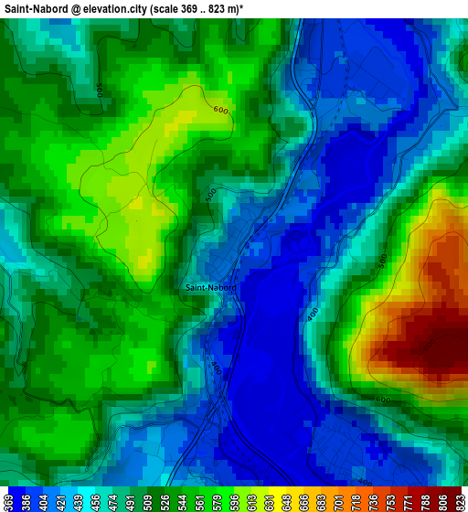
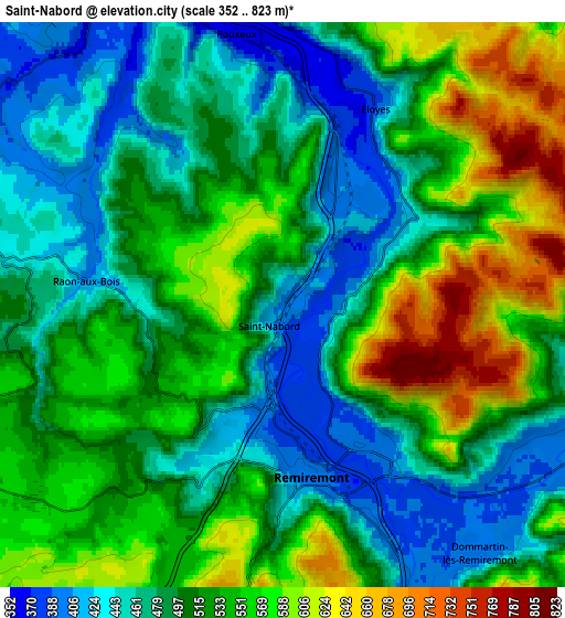
Below is the Elevation map of Saint-Nabord, which displays elevation range with different colors. Scale of the first map is from 369 to 823 m (1211 to 2700 ft) with average elevation of 499.4 meters (=1638 ft) [note 1]
These maps also provides idea of topography and contour of this city, they are displayed at different zoom levels. More info about maps, scale and edge coordinates you can find below images.
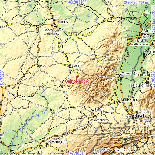
| \ | Map #1 | Map #2 | Topo.Map |
| Scale [m] | 369..823 m | 352..823 m | × |
| Scale [ft] | 1211..2700 ft | 1155..2700 ft | × |
| Average | 499.4 m = 1638 ft | 514.2 m = 1687 ft | × |
| Width | 6.53 km = 4.1 mi | 13.07 km = 8.1 mi | 209 km = 129.9 mi |
| Height | 6.53 km = 4.1 mi | 13.07 km = 8.1 mi | 209 km = 129.9 mi |
| ↑Max Latitude | 48.081077° | 48.110428° | 48.98316° |
| Latitude at center | 48.05171° | 48.05171° | 48.05171° |
| ↓Min Latitude | 48.022326° | 47.992925° | 47.1031° |
| ← Min Longitude | 6.538535° | 6.494589° | 5.17623° |
| Longitude center | 6.58248° | 6.58248° | 6.58248° |
| →Max Longitude | 6.626425° | 6.670371° | 7.98873° |
Nearby cities:
Cities around Saint-Nabord sort by population:
• Remiremont elevation 402 m
3.8 km,  173°
173°
• Saint-Étienne-lès-Remiremont 397 m
3.8 km,  148°
148°
• Éloyes 380 m
5.4 km,  19°
19°
• Hadol 406 m
8.9 km,  298°
298°
• Saint-Amé 395 m
6.8 km,  117°
117°
• Pouxeux 370 m
6.1 km,  353°
353°
• Dommartin-lès-Remiremont 399 m
7.3 km,  143°
143°
• Le Syndicat 393 m
8.5 km, 116°
• Arches 352 m
8.5 km,  331°
331°
• Vecoux 407 m
9.1 km, 153°
• Archettes 353 m
8.6 km,  337°
337°
• Raon-aux-Bois 405 m
4.6 km,  277°
277°
Multilingual:
 En español:
Saint-Nabord elevación 405 m.
 En France:
Saint-Nabord élévation 405 m.
 Auf Deutsch:
Saint-Nabord höhe über dem Meeresspiegel ist 405 m.

Sources and notes:
- [note 1] Map square and city borders are not equal. Map elevation data is calculated only from area inside that square.
- [src 1] Elevation data from geonames database provided with same terms of usage.
- [src 2] The elevation map of Saint-Nabord is generated using elevation data from NASA's 3 arcsec (90m) resolution SRTM data.
- [src 3] Base (background) map © OpenStreetMap contributors tiles are generated by Geofabrik and OpenTopoMap.
Copyright & License:
This Saint-Nabord Elevation Map is licensed under CC BY-SA. You may reuse any part from this page, if you give a proper credit by linking to this URL:
 More info on terms of use page.