Arches elevation
Arches (Grand Est, Vosges), France elevation is 352 meters and Arches elevation in feet is 1155 ft above sea level [src 1]. Arches is a populated place (feature code) with elevation that is 178 meters (584 ft) bigger than average city elevation in France.
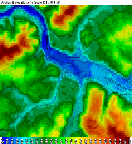
Below is the Elevation map of Arches, which displays elevation range with different colors. Scale of the first map is from 331 to 518 m (1086 to 1699 ft) with average elevation of 403 meters (=1322 ft) [note 1]
These maps also provides idea of topography and contour of this city, they are displayed at different zoom levels. More info about maps, scale and edge coordinates you can find below images.
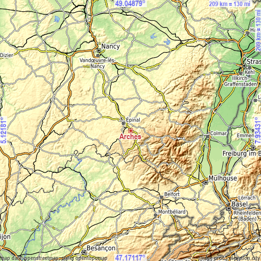
| \ | Map #1 | Topo.Map |
| Scale [m] | 331..518 m | × |
| Scale [ft] | 1086..1699 ft | × |
| Average | 403 m = 1322 ft | × |
| Width | 6.52 km = 4.1 mi | 208.8 km = 129.7 mi |
| Height | 6.52 km = 4.1 mi | 208.8 km = 129.7 mi |
| ↑Max Latitude | 48.147889° | 49.04879° |
| Latitude at center | 48.11856° | 48.11856° |
| ↓Min Latitude | 48.089214° | 47.17117° |
| ← Min Longitude | 6.484115° | 5.12181° |
| Longitude center | 6.52806° | 6.52806° |
| →Max Longitude | 6.572005° | 7.93431° |
Nearby cities:
Cities around Arches sort by population:
• Épinal elevation 365 m
9.1 km,  322°
322°
• Saint-Nabord 405 m
8.5 km,  151°
151°
• Éloyes 380 m
6.3 km,  111°
111°
• Chantraine 384 m
9.1 km,  310°
310°
• Hadol 406 m
5 km,  230°
230°
• Pouxeux 370 m
3.6 km, 112°
• Deyvillers 343 m
9.1 km,  354°
354°
• Uriménil 363 m
9.7 km,  258°
258°
• Cheniménil 374 m
6 km,  68°
68°
• Archettes 353 m
0.9 km,  52°
52°
• Docelles 374 m
6.9 km, 65°
• Raon-aux-Bois 405 m
6.9 km,  184°
184°
Multilingual:
 En español:
Arches elevación 352 m.
 En France:
Arches élévation 352 m.


Sources and notes:
- [note 1] Map square and city borders are not equal. Map elevation data is calculated only from area inside that square.
- [src 1] Elevation data from geonames database provided with same terms of usage.
- [src 2] The elevation map of Arches is generated using elevation data from NASA's 3 arcsec (90m) resolution SRTM data.
- [src 3] Base (background) map © OpenStreetMap contributors tiles are generated by Geofabrik and OpenTopoMap.
Copyright & License:
This Arches Elevation Map is licensed under CC BY-SA. You may reuse any part from this page, if you give a proper credit by linking to this URL:
 More info on terms of use page.