Vecoux elevation
Vecoux (Grand Est, Vosges), France elevation is 407 meters and Vecoux elevation in feet is 1335 ft above sea level [src 1]. Vecoux is a populated place (feature code) with elevation that is 233 meters (764 ft) bigger than average city elevation in France.
Below is the Elevation map of Vecoux, which displays elevation range with different colors. Scale of the first map is from 383 to 892 m (1257 to 2927 ft) with average elevation of 567.7 meters (=1863 ft) [note 1]
These maps also provides idea of topography and contour of this city, they are displayed at different zoom levels. More info about maps, scale and edge coordinates you can find below images.
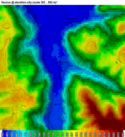
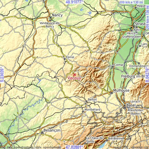
| \ | Map #1 | Topo.Map |
| Scale [m] | 383..892 m | × |
| Scale [ft] | 1257..2927 ft | × |
| Average | 567.7 m = 1863 ft | × |
| Width | 6.54 km = 4.1 mi | 209.3 km = 130.1 mi |
| Height | 6.54 km = 4.1 mi | 209.3 km = 130.1 mi |
| ↑Max Latitude | 48.007379° | 48.91077° |
| Latitude at center | 47.97797° | 47.97797° |
| ↓Min Latitude | 47.948544° | 47.02801° |
| ← Min Longitude | 6.592565° | 5.23026° |
| Longitude center | 6.63651° | 6.63651° |
| →Max Longitude | 6.680455° | 8.04276° |
Nearby cities:
Cities around Vecoux sort by population:
• Remiremont elevation 402 m
5.7 km,  320°
320°
• Saint-Étienne-lès-Remiremont 397 m
5.4 km,  337°
337°
• Saint-Nabord 405 m
9.1 km,  333°
333°
• Vagney 406 m
6.8 km,  62°
62°
• Rupt-sur-Moselle 424 m
6.5 km,  162°
162°
• Saulxures-sur-Moselotte 460 m
10.5 km,  107°
107°
• Saint-Amé 395 m
5.5 km,  21°
21°
• Ramonchamp 474 m
12.2 km,  139°
139°
• Plombières-les-Bains 426 m
13.4 km,  263°
263°
• Dommartin-lès-Remiremont 399 m
2.4 km,  7°
7°
• Le Syndicat 393 m
5.6 km,  39°
39°
• Raon-aux-Bois 405 m
12.3 km, 315°
Multilingual:
 En español:
Vecoux elevación 407 m.
 En France:
Vecoux élévation 407 m.


Sources and notes:
- [note 1] Map square and city borders are not equal. Map elevation data is calculated only from area inside that square.
- [src 1] Elevation data from geonames database provided with same terms of usage.
- [src 2] The elevation map of Vecoux is generated using elevation data from NASA's 3 arcsec (90m) resolution SRTM data.
- [src 3] Base (background) map © OpenStreetMap contributors tiles are generated by Geofabrik and OpenTopoMap.
Copyright & License:
This Vecoux Elevation Map is licensed under CC BY-SA. You may reuse any part from this page, if you give a proper credit by linking to this URL:
 More info on terms of use page.