Saint-Privat elevation
Saint-Privat (Nouvelle-Aquitaine, Département de la Corrèze), France elevation is 581 meters and Saint-Privat elevation in feet is 1906 ft above sea level [src 1]. Saint-Privat is a populated place (feature code) with elevation that is 407 meters (1335 ft) bigger than average city elevation in France.
Below is the Elevation map of Saint-Privat, which displays elevation range with different colors. Scale of the first map is from 499 to 656 m (1637 to 2152 ft) with average elevation of 573.3 meters (=1881 ft) [note 1]
These maps also provides idea of topography and contour of this city, they are displayed at different zoom levels. More info about maps, scale and edge coordinates you can find below images.
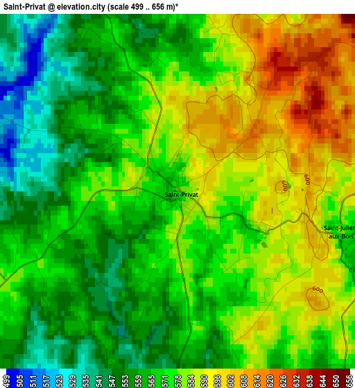
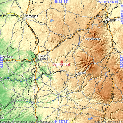
| \ | Map #1 | Topo.Map |
| Scale [m] | 499..656 m | × |
| Scale [ft] | 1637..2152 ft | × |
| Average | 573.3 m = 1881 ft | × |
| Width | 6.89 km = 4.3 mi | 220.6 km = 137.1 mi |
| Height | 6.89 km = 4.3 mi | 220.6 km = 137.1 mi |
| ↑Max Latitude | 45.169301° | 46.12165° |
| Latitude at center | 45.13831° | 45.13831° |
| ↓Min Latitude | 45.107303° | 44.13772° |
| ← Min Longitude | 2.055075° | 0.69277° |
| Longitude center | 2.09902° | 2.09902° |
| →Max Longitude | 2.142965° | 3.50527° |
Nearby cities:
Cities around Saint-Privat sort by population:
• Tulle elevation 307 m
29.3 km,  298°
298°
• Égletons 612 m
30.1 km,  351°
351°
• Mauriac 732 m
20.5 km,  63°
63°
• Argentat 196 m
13.6 km,  248°
248°
• Pleaux 626 m
10 km,  92°
92°
• Sainte-Fortunade 501 m
26.8 km,  286°
286°
• Laguenne 220 m
27.4 km, 294°
• Beaulieu-sur-Dordogne 151 m
27.1 km,  229°
229°
• Beynat 403 m
29.5 km,  267°
267°
• Saint-Cernin 660 m
26.8 km,  109°
109°
• Saint-Paul-des-Landes 552 m
27.5 km,  141°
141°
• Laroquebrou 488 m
20.2 km,  158°
158°
Multilingual:
 En español:
Saint-Privat elevación 581 m.
 En France:
Saint-Privat élévation 581 m.
 Auf Deutsch:
Saint-Privat höhe über dem Meeresspiegel ist 581 m.

Sources and notes:
- [note 1] Map square and city borders are not equal. Map elevation data is calculated only from area inside that square.
- [src 1] Elevation data from geonames database provided with same terms of usage.
- [src 2] The elevation map of Saint-Privat is generated using elevation data from NASA's 3 arcsec (90m) resolution SRTM data.
- [src 3] Base (background) map © OpenStreetMap contributors tiles are generated by Geofabrik and OpenTopoMap.
Copyright & License:
This Saint-Privat Elevation Map is licensed under CC BY-SA. You may reuse any part from this page, if you give a proper credit by linking to this URL:
 More info on terms of use page.