Samatan elevation
Samatan (Occitanie, Gers), France elevation is 173 meters and Samatan elevation in feet is 568 ft above sea level [src 1]. Samatan is a populated place (feature code) with elevation that is 1 meters (3 ft) smaller than average city elevation in France.
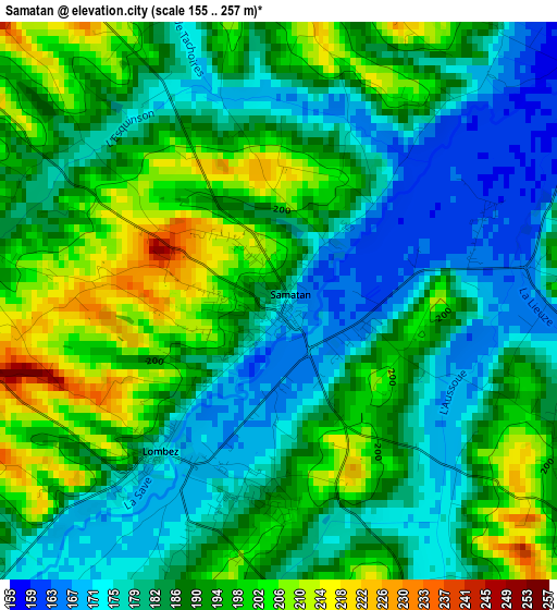
Below is the Elevation map of Samatan, which displays elevation range with different colors. Scale of the first map is from 155 to 257 m (509 to 843 ft) with average elevation of 188.2 meters (=617 ft) [note 1]
These maps also provides idea of topography and contour of this city, they are displayed at different zoom levels. More info about maps, scale and edge coordinates you can find below images.
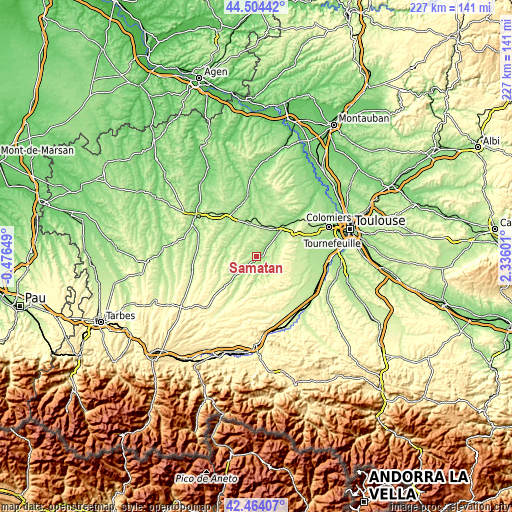
| \ | Map #1 | Topo.Map |
| Scale [m] | 155..257 m | × |
| Scale [ft] | 509..843 ft | × |
| Average | 188.2 m = 617 ft | × |
| Width | 7.09 km = 4.4 mi | 226.9 km = 141 mi |
| Height | 7.09 km = 4.4 mi | 226.9 km = 141 mi |
| ↑Max Latitude | 43.524732° | 44.50442° |
| Latitude at center | 43.49286° | 43.49286° |
| ↓Min Latitude | 43.460971° | 42.46407° |
| ← Min Longitude | 0.885815° | -0.47649° |
| Longitude center | 0.92976° | 0.92976° |
| →Max Longitude | 0.973705° | 2.33601° |
Nearby cities:
Cities around Samatan sort by population:
• L’Isle-Jourdain elevation 158 m
18.1 km,  42°
42°
• Fonsorbes 205 m
24.6 km,  78°
78°
• Saint-Lys 217 m
19.9 km, 84°
• Fontenilles 204 m
22.1 km,  72°
72°
• Rieumes 284 m
17.6 km,  120°
120°
• Gimont 183 m
15.4 km,  343°
343°
• L’Isle-en-Dodon 204 m
14.3 km,  212°
212°
• Sainte-Foy-de-Peyrolières 268 m
17.3 km,  90°
90°
• Bérat 249 m
23.6 km, 122°
• Lombez 175 m
2.5 km,  217°
217°
• Pujaudran 286 m
20.7 km,  58°
58°
• Aubiet 184 m
20.7 km,  325°
325°
Multilingual:
 En español:
Samatan elevación 173 m.
 En France:
Samatan élévation 173 m.


Sources and notes:
- [note 1] Map square and city borders are not equal. Map elevation data is calculated only from area inside that square.
- [src 1] Elevation data from geonames database provided with same terms of usage.
- [src 2] The elevation map of Samatan is generated using elevation data from NASA's 3 arcsec (90m) resolution SRTM data.
- [src 3] Base (background) map © OpenStreetMap contributors tiles are generated by Geofabrik and OpenTopoMap.
Copyright & License:
This Samatan Elevation Map is licensed under CC BY-SA. You may reuse any part from this page, if you give a proper credit by linking to this URL:
 More info on terms of use page.