L’Isle-en-Dodon elevation
L’Isle-en-Dodon (Occitanie, Haute-Garonne), France elevation is 204 meters and L’Isle-en-Dodon elevation in feet is 669 ft above sea level [src 1]. L’Isle-en-Dodon is a populated place (feature code) with elevation that is 30 meters (98 ft) bigger than average city elevation in France.
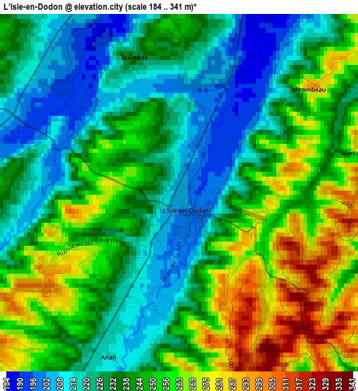
Below is the Elevation map of L’Isle-en-Dodon, which displays elevation range with different colors. Scale of the first map is from 184 to 341 m (604 to 1119 ft) with average elevation of 241.2 meters (=791 ft) [note 1]
These maps also provides idea of topography and contour of this city, they are displayed at different zoom levels. More info about maps, scale and edge coordinates you can find below images.
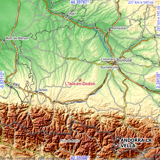
| \ | Map #1 | Topo.Map |
| Scale [m] | 184..341 m | × |
| Scale [ft] | 604..1119 ft | × |
| Average | 241.2 m = 791 ft | × |
| Width | 7.1 km = 4.4 mi | 227.3 km = 141.2 mi |
| Height | 7.1 km = 4.4 mi | 227.3 km = 141.2 mi |
| ↑Max Latitude | 43.416209° | 44.39767° |
| Latitude at center | 43.38428° | 43.38428° |
| ↓Min Latitude | 43.352334° | 42.35366° |
| ← Min Longitude | 0.791185° | -0.57112° |
| Longitude center | 0.83513° | 0.83513° |
| →Max Longitude | 0.879075° | 2.24138° |
Nearby cities:
Cities around L’Isle-en-Dodon sort by population:
• Rieumes elevation 284 m
23 km,  82°
82°
• Gimont 183 m
27.1 km,  7°
7°
• Samatan 173 m
14.3 km,  32°
32°
• Martres-Tolosane 273 m
25 km,  145°
145°
• Boulogne-sur-Gesse 334 m
17.7 km,  237°
237°
• Le Fousseret 306 m
21.9 km,  121°
121°
• Sainte-Foy-de-Peyrolières 268 m
27.8 km,  64°
64°
• Bérat 249 m
27.5 km,  91°
91°
• Masseube 211 m
21.4 km,  283°
283°
• Lombez 175 m
11.8 km, 31°
• Aurignac 392 m
19 km,  168°
168°
• Seissan 189 m
23 km,  301°
301°
Multilingual:
 En español:
L’Isle-en-Dodon elevación 204 m.
 En France:
L’Isle-en-Dodon élévation 204 m.
 Auf Deutsch:
L’Isle-en-Dodon höhe über dem Meeresspiegel ist 204 m.

Sources and notes:
- [note 1] Map square and city borders are not equal. Map elevation data is calculated only from area inside that square.
- [src 1] Elevation data from geonames database provided with same terms of usage.
- [src 2] The elevation map of L’Isle-en-Dodon is generated using elevation data from NASA's 3 arcsec (90m) resolution SRTM data.
- [src 3] Base (background) map © OpenStreetMap contributors tiles are generated by Geofabrik and OpenTopoMap.
Copyright & License:
This L’Isle-en-Dodon Elevation Map is licensed under CC BY-SA. You may reuse any part from this page, if you give a proper credit by linking to this URL:
 More info on terms of use page.