L’Isle-Jourdain elevation
L’Isle-Jourdain (Occitanie, Gers), France elevation is 158 meters and L’Isle-Jourdain elevation in feet is 518 ft above sea level [src 1]. L’Isle-Jourdain is a populated place (feature code) with elevation that is 16 meters (52 ft) smaller than average city elevation in France.
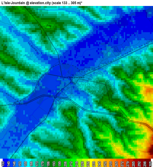
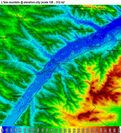
Below is the Elevation map of L’Isle-Jourdain, which displays elevation range with different colors. Scale of the first map is from 133 to 305 m (436 to 1001 ft) with average elevation of 170.9 meters (=561 ft) [note 1]
These maps also provides idea of topography and contour of this city, they are displayed at different zoom levels. More info about maps, scale and edge coordinates you can find below images.
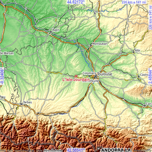
| \ | Map #1 | Map #2 | Topo.Map |
| Scale [m] | 133..305 m | 128..312 m | × |
| Scale [ft] | 436..1001 ft | 420..1024 ft | × |
| Average | 170.9 m = 561 ft | 192.3 m = 631 ft | × |
| Width | 7.08 km = 4.4 mi | 14.15 km = 8.8 mi | 226.4 km = 140.7 mi |
| Height | 7.08 km = 4.4 mi | 14.15 km = 8.8 mi | 226.4 km = 140.7 mi |
| ↑Max Latitude | 43.643989° | 43.675781° | 44.62172° |
| Latitude at center | 43.61218° | 43.61218° | 43.61218° |
| ↓Min Latitude | 43.580354° | 43.548511° | 42.58541° |
| ← Min Longitude | 1.038245° | 0.994299° | -0.32406° |
| Longitude center | 1.08219° | 1.08219° | 1.08219° |
| →Max Longitude | 1.126135° | 1.170081° | 2.48844° |
Nearby cities:
Cities around L’Isle-Jourdain sort by population:
• Pibrac elevation 163 m
16.4 km,  86°
86°
• Fonsorbes 205 m
14.6 km,  125°
125°
• Léguevin 195 m
12.2 km,  96°
96°
• La Salvetat-Saint-Gilles 191 m
15.8 km, 104°
• Saint-Lys 217 m
13.5 km,  146°
146°
• Fontenilles 204 m
11 km, 126°
• Gimont 183 m
16.6 km,  275°
275°
• Brax 190 m
12.7 km, 87°
• Lévignac 168 m
11.3 km,  57°
57°
• Sainte-Foy-de-Peyrolières 268 m
14.2 km,  159°
159°
• Montaigut-sur-Save 141 m
14.8 km,  54°
54°
• Pujaudran 286 m
6 km,  114°
114°
Multilingual:
 En español:
L’Isle-Jourdain elevación 158 m.
 En France:
L’Isle-Jourdain élévation 158 m.
 Auf Deutsch:
L’Isle-Jourdain höhe über dem Meeresspiegel ist 158 m.

Sources and notes:
- [note 1] Map square and city borders are not equal. Map elevation data is calculated only from area inside that square.
- [src 1] Elevation data from geonames database provided with same terms of usage.
- [src 2] The elevation map of L’Isle-Jourdain is generated using elevation data from NASA's 3 arcsec (90m) resolution SRTM data.
- [src 3] Base (background) map © OpenStreetMap contributors tiles are generated by Geofabrik and OpenTopoMap.
Copyright & License:
This L’Isle-Jourdain Elevation Map is licensed under CC BY-SA. You may reuse any part from this page, if you give a proper credit by linking to this URL:
 More info on terms of use page.