Léguevin elevation
Léguevin (Occitanie, Haute-Garonne), France elevation is 195 meters and Léguevin elevation in feet is 640 ft above sea level [src 1]. Léguevin is a populated place (feature code) with elevation that is 21 meters (69 ft) bigger than average city elevation in France.
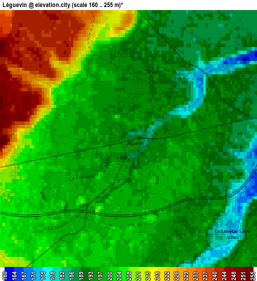
Below is the Elevation map of Léguevin, which displays elevation range with different colors. Scale of the first map is from 160 to 255 m (525 to 837 ft) with average elevation of 200.7 meters (=658 ft) [note 1]
These maps also provides idea of topography and contour of this city, they are displayed at different zoom levels. More info about maps, scale and edge coordinates you can find below images.
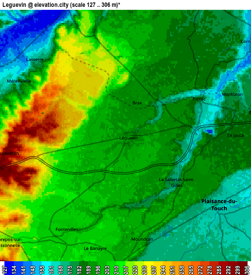
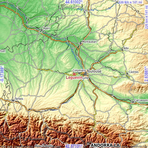
| \ | Map #1 | Map #2 | Topo.Map |
| Scale [m] | 160..255 m | 127..306 m | × |
| Scale [ft] | 525..837 ft | 417..1004 ft | × |
| Average | 200.7 m = 658 ft | 198 m = 650 ft | × |
| Width | 7.08 km = 4.4 mi | 14.15 km = 8.8 mi | 226.5 km = 140.7 mi |
| Height | 7.08 km = 4.4 mi | 14.15 km = 8.8 mi | 226.5 km = 140.7 mi |
| ↑Max Latitude | 43.632095° | 43.663894° | 44.61002° |
| Latitude at center | 43.60028° | 43.60028° | 43.60028° |
| ↓Min Latitude | 43.568448° | 43.536599° | 42.57331° |
| ← Min Longitude | 1.188415° | 1.144469° | -0.17389° |
| Longitude center | 1.23236° | 1.23236° | 1.23236° |
| →Max Longitude | 1.276305° | 1.320251° | 2.63861° |
Nearby cities:
Cities around Léguevin sort by population:
• Colomiers elevation 186 m
8.3 km,  82°
82°
• Tournefeuille 189 m
7.1 km,  100°
100°
• Plaisance-du-Touch 168 m
6.5 km,  126°
126°
• Pibrac 163 m
4.8 km,  62°
62°
• Fonsorbes 205 m
7.2 km,  181°
181°
• La Salvetat-Saint-Gilles 191 m
4.2 km, 130°
• Cornebarrieu 150 m
9.2 km,  53°
53°
• Fontenilles 204 m
6.2 km,  212°
212°
• Brax 190 m
2 km,  16°
16°
• Mondonville 182 m
9.2 km,  28°
28°
• Lévignac 168 m
7.8 km,  340°
340°
• Pujaudran 286 m
6.8 km,  259°
259°
Multilingual:
 En español:
Léguevin elevación 195 m.
 En France:
Léguevin élévation 195 m.
 Auf Deutsch:
Léguevin höhe über dem Meeresspiegel ist 195 m.

Sources and notes:
- [note 1] Map square and city borders are not equal. Map elevation data is calculated only from area inside that square.
- [src 1] Elevation data from geonames database provided with same terms of usage.
- [src 2] The elevation map of Léguevin is generated using elevation data from NASA's 3 arcsec (90m) resolution SRTM data.
- [src 3] Base (background) map © OpenStreetMap contributors tiles are generated by Geofabrik and OpenTopoMap.
Copyright & License:
This Léguevin Elevation Map is licensed under CC BY-SA. You may reuse any part from this page, if you give a proper credit by linking to this URL:
 More info on terms of use page.