Tonquédec elevation
Tonquédec (Brittany, Département des Côtes-d’Armor), France elevation is 93 meters and Tonquédec elevation in feet is 305 ft above sea level [src 1]. Tonquédec is a populated place (feature code) with elevation that is 81 meters (266 ft) smaller than average city elevation in France.
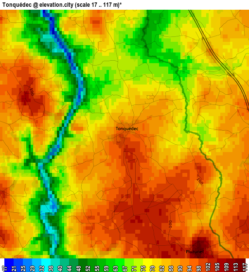
Below is the Elevation map of Tonquédec, which displays elevation range with different colors. Scale of the first map is from 17 to 117 m (56 to 384 ft) with average elevation of 81.3 meters (=267 ft) [note 1]
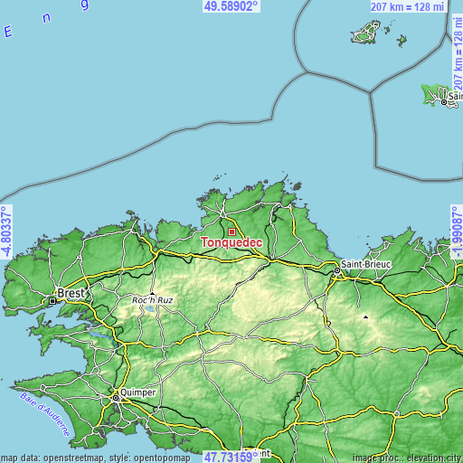
These maps also provides idea of topography and contour of this city, they are displayed at different zoom levels. More info about maps, scale and edge coordinates you can find below images.
| \ | Map #1 | Topo.Map |
| Scale [m] | 17..117 m | × |
| Scale [ft] | 56..384 ft | × |
| Average | 81.3 m = 267 ft | × |
| Width | 6.45 km = 4 mi | 206.5 km = 128.3 mi |
| Height | 6.45 km = 4 mi | 206.5 km = 128.3 mi |
| ↑Max Latitude | 48.697874° | 49.58902° |
| Latitude at center | 48.66886° | 48.66886° |
| ↓Min Latitude | 48.63983° | 47.73159° |
| ← Min Longitude | -3.441065° | -4.80337° |
| Longitude center | -3.39712° | -3.39712° |
| →Max Longitude | -3.353175° | -1.99087° |
Nearby cities:
Cities around Tonquédec sort by population:
• Lannion elevation 40 m
8.3 km,  328°
328°
• Bégard 144 m
8.4 km,  122°
122°
• Ploubezre 83 m
5.2 km,  311°
311°
• Ploumilliau 109 m
8.9 km,  280°
280°
• Plouaret 114 m
7.7 km,  221°
221°
• Pédernec 128 m
12.3 km,  130°
130°
• Rospez 80 m
6.8 km,  8°
8°
• Plounévez-Moëdec 178 m
12 km,  198°
198°
• Cavan 97 m
3.8 km,  83°
83°
• Le Vieux-Marché 133 m
8.6 km,  206°
206°
• Prat 80 m
7.4 km, 83°
• Pluzunet 116 m
3.7 km,  148°
148°
Multilingual:
 En español:
Tonquédec elevación 93 m.
 En France:
Tonquédec élévation 93 m.
 Auf Deutsch:
Tonquédec höhe über dem Meeresspiegel ist 93 m.

Sources and notes:
- [note 1] Map square and city borders are not equal. Map elevation data is calculated only from area inside that square.
- [src 1] Elevation data from geonames database provided with same terms of usage.
- [src 2] The elevation map of Tonquédec is generated using elevation data from NASA's 3 arcsec (90m) resolution SRTM data.
- [src 3] Base (background) map © OpenStreetMap contributors tiles are generated by Geofabrik and OpenTopoMap.
Copyright & License:
This Tonquédec Elevation Map is licensed under CC BY-SA. You may reuse any part from this page, if you give a proper credit by linking to this URL:
 More info on terms of use page.