Lannion elevation
Lannion (Brittany, Département des Côtes-d’Armor), France elevation is 40 meters and Lannion elevation in feet is 131 ft above sea level [src 1]. Lannion is a seat of a third-order administrative division (feature code) with elevation that is 134 meters (440 ft) smaller than average city elevation in France.
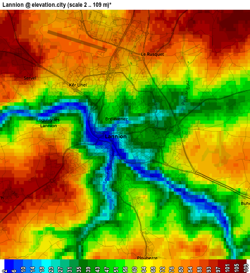
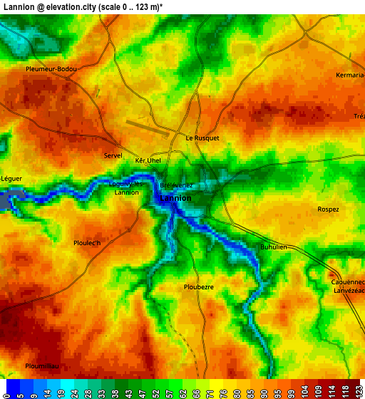
Below is the Elevation map of Lannion, which displays elevation range with different colors. Scale of the first map is from 2 to 109 m (7 to 358 ft) with average elevation of 64.8 meters (=213 ft) [note 1]
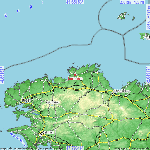
These maps also provides idea of topography and contour of this city, they are displayed at different zoom levels. More info about maps, scale and edge coordinates you can find below images.
| \ | Map #1 | Map #2 | Topo.Map |
| Scale [m] | 2..109 m | 0..123 m | × |
| Scale [ft] | 7..358 ft | 0..404 ft | × |
| Average | 64.8 m = 213 ft | 75.3 m = 247 ft | × |
| Width | 6.45 km = 4 mi | 12.89 km = 8 mi | 206.3 km = 128.2 mi |
| Height | 6.45 km = 4 mi | 12.89 km = 8 mi | 206.3 km = 128.2 mi |
| ↑Max Latitude | 48.761527° | 48.790487° | 49.65153° |
| Latitude at center | 48.73255° | 48.73255° | 48.73255° |
| ↓Min Latitude | 48.703556° | 48.674546° | 47.79646° |
| ← Min Longitude | -3.499365° | -3.543311° | -4.86167° |
| Longitude center | -3.45542° | -3.45542° | -3.45542° |
| →Max Longitude | -3.411475° | -3.367529° | -2.04917° |
Nearby cities:
Cities around Lannion sort by population:
• Perros-Guirec elevation 49 m
9.2 km,  7°
7°
• Pleumeur-Bodou 105 m
5.9 km,  310°
310°
• Trébeurden 77 m
9 km,  294°
294°
• Ploubezre 83 m
3.6 km,  173°
173°
• Louannec 58 m
7.6 km,  24°
24°
• Trégastel 34 m
9.9 km,  340°
340°
• Ploumilliau 109 m
7.1 km,  219°
219°
• Rospez 80 m
5.3 km,  93°
93°
• Saint-Quay-Perros 56 m
5.7 km,  4°
4°
• Trédrez-Locquémeau 85 m
8.9 km,  246°
246°
• Locquémeau 44 m
7.9 km,  263°
263°
• Tonquédec 93 m
8.3 km,  148°
148°
Multilingual:
 En español:
Lannion elevación 40 m.
 En France:
Lannion élévation 40 m.


Sources and notes:
- [note 1] Map square and city borders are not equal. Map elevation data is calculated only from area inside that square.
- [src 1] Elevation data from geonames database provided with same terms of usage.
- [src 2] The elevation map of Lannion is generated using elevation data from NASA's 3 arcsec (90m) resolution SRTM data.
- [src 3] Base (background) map © OpenStreetMap contributors tiles are generated by Geofabrik and OpenTopoMap.
Copyright & License:
This Lannion Elevation Map is licensed under CC BY-SA. You may reuse any part from this page, if you give a proper credit by linking to this URL:
 More info on terms of use page.