Tournon-sur-Rhône elevation
Tournon-sur-Rhône (Auvergne-Rhône-Alpes, Département de l'Ardèche), France elevation is 130 meters and Tournon-sur-Rhône elevation in feet is 427 ft above sea level [src 1]. Tournon-sur-Rhône is a seat of a third-order administrative division (feature code) with elevation that is 44 meters (144 ft) smaller than average city elevation in France.
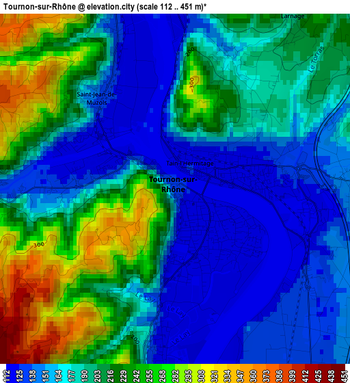
Below is the Elevation map of Tournon-sur-Rhône, which displays elevation range with different colors. Scale of the first map is from 112 to 451 m (367 to 1480 ft) with average elevation of 193 meters (=633 ft) [note 1]
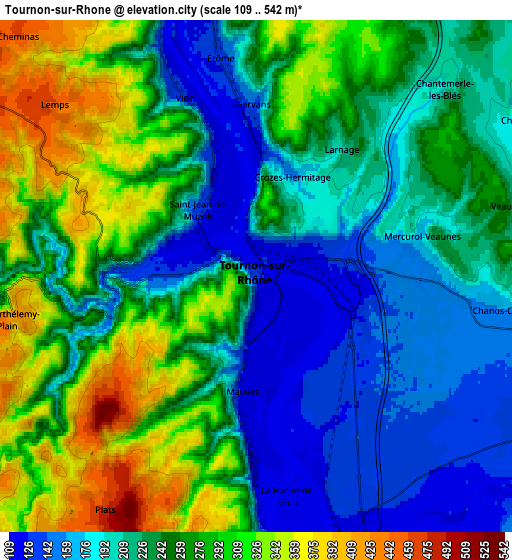
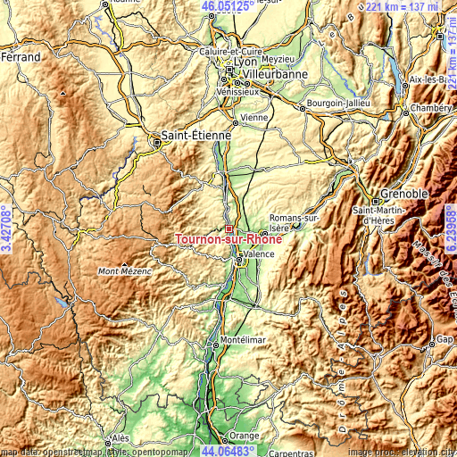
These maps also provides idea of topography and contour of this city, they are displayed at different zoom levels. More info about maps, scale and edge coordinates you can find below images.
| \ | Map #1 | Map #2 | Topo.Map |
| Scale [m] | 112..451 m | 109..542 m | × |
| Scale [ft] | 367..1480 ft | 358..1778 ft | × |
| Average | 193 m = 633 ft | 243.1 m = 798 ft | × |
| Width | 6.9 km = 4.3 mi | 13.8 km = 8.6 mi | 220.9 km = 137.3 mi |
| Height | 6.9 km = 4.3 mi | 13.8 km = 8.6 mi | 220.9 km = 137.3 mi |
| ↑Max Latitude | 45.097699° | 45.128712° | 46.05125° |
| Latitude at center | 45.06667° | 45.06667° | 45.06667° |
| ↓Min Latitude | 45.035624° | 45.004561° | 44.06483° |
| ← Min Longitude | 4.789385° | 4.745439° | 3.42708° |
| Longitude center | 4.83333° | 4.83333° | 4.83333° |
| →Max Longitude | 4.877275° | 4.921221° | 6.23958° |
Nearby cities:
Cities around Tournon-sur-Rhône sort by population:
• Tain-l’Hermitage elevation 132 m
1.8 km,  89°
89°
• Saint-Vallier 220 m
11.7 km,  353°
353°
• Châteauneuf-sur-Isère 128 m
9.6 km,  125°
125°
• La Roche-de-Glun 120 m
6 km,  171°
171°
• Saint-Jean-de-Muzols 122 m
2.3 km,  317°
317°
• Cornas 126 m
11.5 km, 174°
• Clérieux 226 m
10 km,  84°
84°
• Mercurol-Veaunes 192 m
4.7 km, 79°
• Saint-Barthélemy-de-Vals 176 m
11.8 km,  14°
14°
• Mauves 116 m
3.2 km,  185°
185°
• Chanos-Curson 222 m
7.1 km,  95°
95°
• Beaumont-Monteux 135 m
8.5 km, 127°
Multilingual:
 En español:
Tournon-sur-Rhône elevación 130 m.
 En France:
Tournon-sur-Rhône élévation 130 m.
 Auf Deutsch:
Tournon-sur-Rhône höhe über dem Meeresspiegel ist 130 m.

Sources and notes:
- [note 1] Map square and city borders are not equal. Map elevation data is calculated only from area inside that square.
- [src 1] Elevation data from geonames database provided with same terms of usage.
- [src 2] The elevation map of Tournon-sur-Rhône is generated using elevation data from NASA's 3 arcsec (90m) resolution SRTM data.
- [src 3] Base (background) map © OpenStreetMap contributors tiles are generated by Geofabrik and OpenTopoMap.
Copyright & License:
This Tournon-sur-Rhône Elevation Map is licensed under CC BY-SA. You may reuse any part from this page, if you give a proper credit by linking to this URL:
 More info on terms of use page.