Us elevation
Us (Île-de-France, Département du Val-d’Oise), France elevation is 70 meters and Us elevation in feet is 230 ft above sea level [src 1]. Us is a populated place (feature code) with elevation that is 104 meters (341 ft) smaller than average city elevation in France.
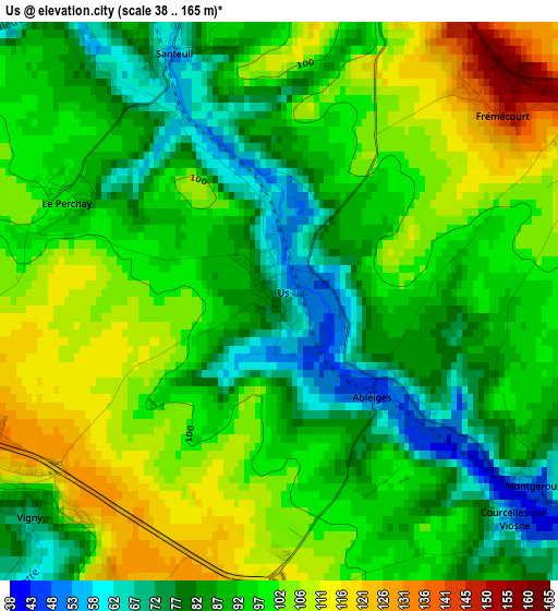
Below is the Elevation map of Us, which displays elevation range with different colors. Scale of the first map is from 38 to 165 m (125 to 541 ft) with average elevation of 93.6 meters (=307 ft) [note 1]
These maps also provides idea of topography and contour of this city, they are displayed at different zoom levels. More info about maps, scale and edge coordinates you can find below images.
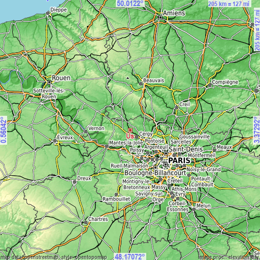
| \ | Map #1 | Topo.Map |
| Scale [m] | 38..165 m | × |
| Scale [ft] | 125..541 ft | × |
| Average | 93.6 m = 307 ft | × |
| Width | 6.4 km = 4 mi | 204.8 km = 127.3 mi |
| Height | 6.4 km = 4 mi | 204.7 km = 127.2 mi |
| ↑Max Latitude | 49.128764° | 50.0122° |
| Latitude at center | 49.1° | 49.1° |
| ↓Min Latitude | 49.071219° | 48.17072° |
| ← Min Longitude | 1.922725° | 0.56042° |
| Longitude center | 1.96667° | 1.96667° |
| →Max Longitude | 2.010615° | 3.37292° |
Nearby cities:
Cities around Us sort by population:
• Vauréal elevation 41 m
8.9 km,  146°
146°
• Osny 91 m
7.7 km,  115°
115°
• Courdimanche 156 m
7.6 km,  160°
160°
• Menucourt 102 m
8 km,  172°
172°
• Vaux-sur-Seine 117 m
9.7 km,  178°
178°
• Marines 118 m
5.1 km,  12°
12°
• Ennery 94 m
10.5 km,  105°
105°
• Chars 64 m
7.1 km,  341°
341°
• Seraincourt 40 m
10.2 km,  225°
225°
• Sagy 51 m
5.7 km,  190°
190°
• Vigny 79 m
3.7 km, 230°
• Ableiges 54 m
1.6 km,  137°
137°


Sources and notes:
- [note 1] Map square and city borders are not equal. Map elevation data is calculated only from area inside that square.
- [src 1] Elevation data from geonames database provided with same terms of usage.
- [src 2] The elevation map of Us is generated using elevation data from NASA's 3 arcsec (90m) resolution SRTM data.
- [src 3] Base (background) map © OpenStreetMap contributors tiles are generated by Geofabrik and OpenTopoMap.
Copyright & License:
This Us Elevation Map is licensed under CC BY-SA. You may reuse any part from this page, if you give a proper credit by linking to this URL:
 More info on terms of use page.