Vire elevation
Vire (Normandy, Calvados), France elevation is 200 meters and Vire elevation in feet is 656 ft above sea level [src 1]. Vire is a seat of a third-order administrative division (feature code) with elevation that is 26 meters (85 ft) bigger than average city elevation in France.
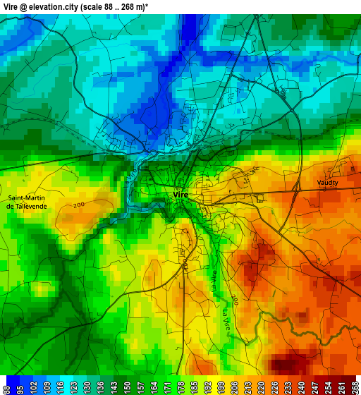
Below is the Elevation map of Vire, which displays elevation range with different colors. Scale of the first map is from 88 to 268 m (289 to 879 ft) with average elevation of 166.1 meters (=545 ft) [note 1]
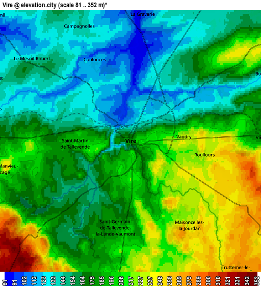
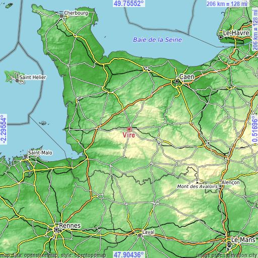
These maps also provides idea of topography and contour of this city, they are displayed at different zoom levels. More info about maps, scale and edge coordinates you can find below images.
| \ | Map #1 | Map #2 | Topo.Map |
| Scale [m] | 88..268 m | 81..352 m | × |
| Scale [ft] | 289..879 ft | 266..1155 ft | × |
| Average | 166.1 m = 545 ft | 179.8 m = 590 ft | × |
| Width | 6.43 km = 4 mi | 12.86 km = 8 mi | 205.8 km = 127.9 mi |
| Height | 6.43 km = 4 mi | 12.86 km = 8 mi | 205.8 km = 127.9 mi |
| ↑Max Latitude | 48.867406° | 48.896305° | 49.75552° |
| Latitude at center | 48.83849° | 48.83849° | 48.83849° |
| ↓Min Latitude | 48.809558° | 48.780608° | 47.90436° |
| ← Min Longitude | -0.933235° | -0.977181° | -2.29554° |
| Longitude center | -0.88929° | -0.88929° | -0.88929° |
| →Max Longitude | -0.845345° | -0.801399° | 0.51696° |
Nearby cities:
Cities around Vire sort by population:
• Sourdeval elevation 213 m
13.1 km,  190°
190°
• Tinchebray 206 m
14.1 km,  125°
125°
• Mortain 236 m
21.5 km, 190°
• Le Theil-Bocage 218 m
13.6 km,  68°
68°
• La Lande-Patry 207 m
22.9 km,  111°
111°
• Vassy 150 m
15.8 km,  83°
83°
• Vaudry 226 m
2.7 km, 83°
• Saint-Sever-Calvados 212 m
11.6 km,  271°
271°
• Tessy-sur-Vire 60 m
19.6 km,  320°
320°
• Chanu 280 m
19.8 km, 127°
• Saint-Martin-des-Besaces 210 m
19.4 km,  9°
9°
• Romagny 153 m
22.9 km, 194°
Multilingual:
 En español:
Vire elevación 200 m.
 En France:
Vire élévation 200 m.


Sources and notes:
- [note 1] Map square and city borders are not equal. Map elevation data is calculated only from area inside that square.
- [src 1] Elevation data from geonames database provided with same terms of usage.
- [src 2] The elevation map of Vire is generated using elevation data from NASA's 3 arcsec (90m) resolution SRTM data.
- [src 3] Base (background) map © OpenStreetMap contributors tiles are generated by Geofabrik and OpenTopoMap.
Copyright & License:
This Vire Elevation Map is licensed under CC BY-SA. You may reuse any part from this page, if you give a proper credit by linking to this URL:
 More info on terms of use page.