Tinchebray elevation
Tinchebray (Normandy, Département de l'Orne), France elevation is 206 meters and Tinchebray elevation in feet is 676 ft above sea level [src 1]. Tinchebray is a populated place (feature code) with elevation that is 32 meters (105 ft) bigger than average city elevation in France.
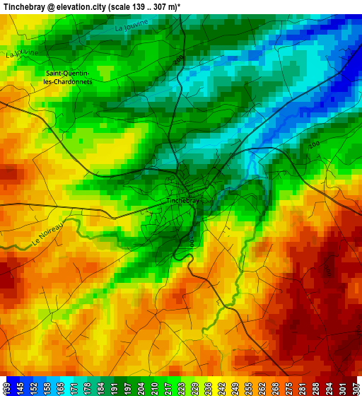
Below is the Elevation map of Tinchebray, which displays elevation range with different colors. Scale of the first map is from 139 to 307 m (456 to 1007 ft) with average elevation of 227.6 meters (=747 ft) [note 1]
These maps also provides idea of topography and contour of this city, they are displayed at different zoom levels. More info about maps, scale and edge coordinates you can find below images.
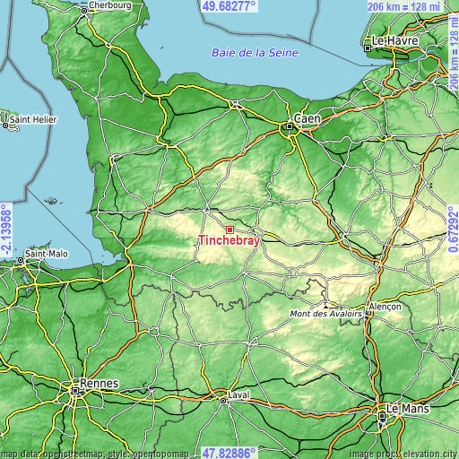
| \ | Map #1 | Topo.Map |
| Scale [m] | 139..307 m | × |
| Scale [ft] | 456..1007 ft | × |
| Average | 227.6 m = 747 ft | × |
| Width | 6.44 km = 4 mi | 206.1 km = 128.1 mi |
| Height | 6.44 km = 4 mi | 206.1 km = 128.1 mi |
| ↑Max Latitude | 48.793329° | 49.68277° |
| Latitude at center | 48.76437° | 48.76437° |
| ↓Min Latitude | 48.735395° | 47.82886° |
| ← Min Longitude | -0.777275° | -2.13958° |
| Longitude center | -0.73333° | -0.73333° |
| →Max Longitude | -0.689385° | 0.67292° |
Nearby cities:
Cities around Tinchebray sort by population:
• Flers elevation 206 m
12 km,  104°
104°
• Vire 200 m
14.1 km,  305°
305°
• Saint-Georges-des-Groseillers 222 m
12.2 km,  87°
87°
• Sourdeval 213 m
14.6 km,  251°
251°
• Le Theil-Bocage 218 m
13.3 km,  5°
5°
• Messei 216 m
15.5 km,  112°
112°
• La Lande-Patry 207 m
9.9 km, 91°
• Vassy 150 m
10.8 km,  23°
23°
• Vaudry 226 m
12.3 km, 314°
• La Selle-la-Forge 214 m
14.5 km, 103°
• Saint-Pierre-du-Regard 126 m
16.2 km,  57°
57°
• Chanu 280 m
5.7 km,  132°
132°
Multilingual:
 En español:
Tinchebray elevación 206 m.
 En France:
Tinchebray élévation 206 m.
 Auf Deutsch:
Tinchebray höhe über dem Meeresspiegel ist 206 m.

Sources and notes:
- [note 1] Map square and city borders are not equal. Map elevation data is calculated only from area inside that square.
- [src 1] Elevation data from geonames database provided with same terms of usage.
- [src 2] The elevation map of Tinchebray is generated using elevation data from NASA's 3 arcsec (90m) resolution SRTM data.
- [src 3] Base (background) map © OpenStreetMap contributors tiles are generated by Geofabrik and OpenTopoMap.
Copyright & License:
This Tinchebray Elevation Map is licensed under CC BY-SA. You may reuse any part from this page, if you give a proper credit by linking to this URL:
 More info on terms of use page.