Vouziers elevation
Vouziers (Grand Est, Ardennes), France elevation is 95 meters and Vouziers elevation in feet is 312 ft above sea level [src 1]. Vouziers is a seat of a third-order administrative division (feature code) with elevation that is 79 meters (259 ft) smaller than average city elevation in France.
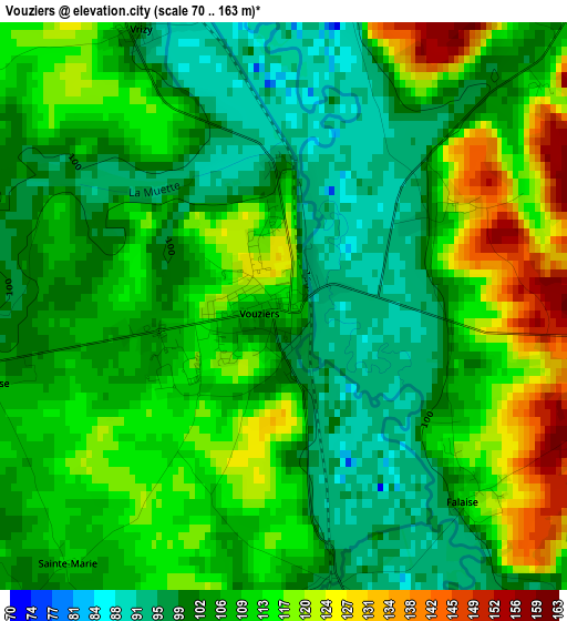
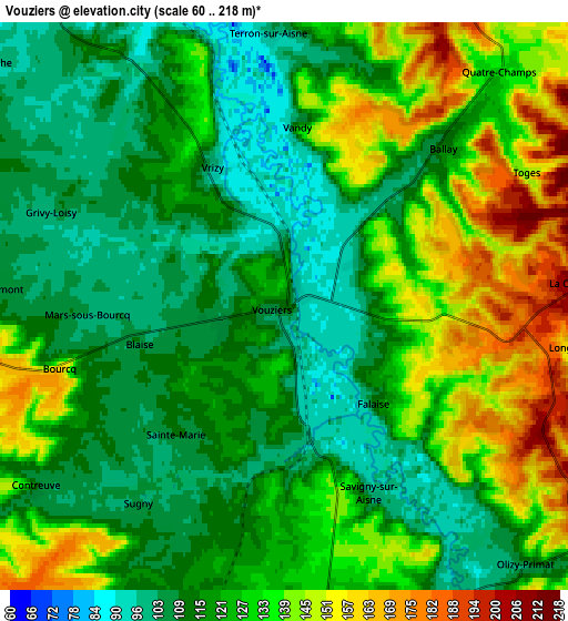
Below is the Elevation map of Vouziers, which displays elevation range with different colors. Scale of the first map is from 70 to 163 m (230 to 535 ft) with average elevation of 108.3 meters (=355 ft) [note 1]
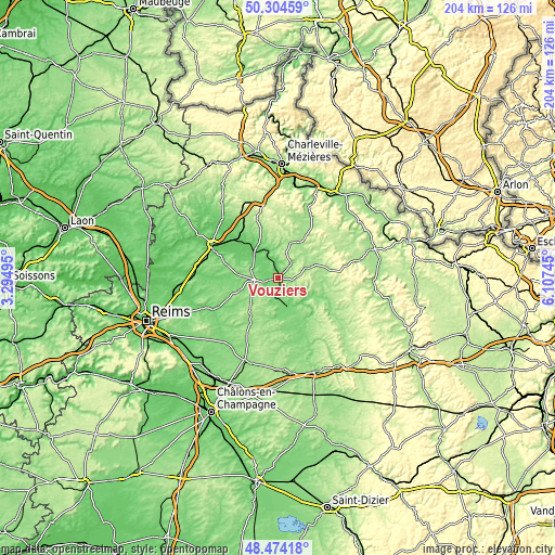
These maps also provides idea of topography and contour of this city, they are displayed at different zoom levels. More info about maps, scale and edge coordinates you can find below images.
| \ | Map #1 | Map #2 | Topo.Map |
| Scale [m] | 70..163 m | 60..218 m | × |
| Scale [ft] | 230..535 ft | 197..715 ft | × |
| Average | 108.3 m = 355 ft | 124.3 m = 408 ft | × |
| Width | 6.36 km = 4 mi | 12.72 km = 7.9 mi | 203.5 km = 126.4 mi |
| Height | 6.36 km = 4 mi | 12.72 km = 7.9 mi | 203.5 km = 126.4 mi |
| ↑Max Latitude | 49.426501° | 49.455076° | 50.30459° |
| Latitude at center | 49.39791° | 49.39791° | 49.39791° |
| ↓Min Latitude | 49.369302° | 49.340677° | 48.47418° |
| ← Min Longitude | 4.657255° | 4.613309° | 3.29495° |
| Longitude center | 4.7012° | 4.7012° | 4.7012° |
| →Max Longitude | 4.745145° | 4.789091° | 6.10745° |
Nearby cities:
Cities around Vouziers sort by population:
• Rethel elevation 105 m
27.1 km,  297°
297°
• Suippes 135 m
32.3 km,  202°
202°
• Mouzon 158 m
35.7 km,  49°
49°
• Donchery 151 m
35.4 km,  20°
20°
• Nouvion-sur-Meuse 154 m
34.2 km,  11°
11°
• Warmeriville 80 m
35.3 km,  261°
261°
• Sault-lès-Rethel 72 m
27 km,  294°
294°
• Pontfaverger-Moronvilliers 103 m
30 km,  248°
248°
• Château-Porcien 67 m
36 km, 293°
• Flize 160 m
33.8 km, 8°
• Attigny 85 m
12.6 km,  315°
315°
• Dom-le-Mesnil 162 m
33.3 km, 12°
Multilingual:
 En español:
Vouziers elevación 95 m.
 En France:
Vouziers élévation 95 m.


Sources and notes:
- [note 1] Map square and city borders are not equal. Map elevation data is calculated only from area inside that square.
- [src 1] Elevation data from geonames database provided with same terms of usage.
- [src 2] The elevation map of Vouziers is generated using elevation data from NASA's 3 arcsec (90m) resolution SRTM data.
- [src 3] Base (background) map © OpenStreetMap contributors tiles are generated by Geofabrik and OpenTopoMap.
Copyright & License:
This Vouziers Elevation Map is licensed under CC BY-SA. You may reuse any part from this page, if you give a proper credit by linking to this URL:
 More info on terms of use page.