Keuruu elevation
Keuruu (Central Finland), Finland elevation is 118 meters and Keuruu elevation in feet is 387 ft above sea level [src 1]. Keuruu is a seat of a third-order administrative division (feature code) with elevation that is 41 meters (135 ft) bigger than average city elevation in Finland.
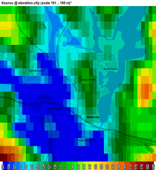
Below is the Elevation map of Keuruu, which displays elevation range with different colors. Scale of the first map is from 101 to 185 m (331 to 607 ft) with average elevation of 121.3 meters (=398 ft) [note 1]
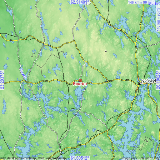
These maps also provides idea of topography and contour of this city, they are displayed at different zoom levels. More info about maps, scale and edge coordinates you can find below images.
| \ | Map #1 | Map #2 | Topo.Map |
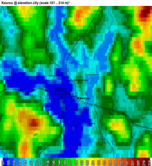
| Scale [m] | 101..185 m | 101..214 m | × |
| Scale [ft] | 331..607 ft | 331..702 ft | × |
| Average | 121.3 m = 398 ft | 135.5 m = 445 ft | × |
| Width | 4.55 km = 2.8 mi | 9.1 km = 5.7 mi | 145.5 km = 90.4 mi |
| Height | 4.55 km = 2.8 mi | 9.1 km = 5.7 mi | 145.5 km = 90.4 mi |
| ↑Max Latitude | 62.287113° | 62.307543° | 62.91401° |
| Latitude at center | 62.26667° | 62.26667° | 62.26667° |
| ↓Min Latitude | 62.246213° | 62.225742° | 61.60512° |
| ← Min Longitude | 24.656055° | 24.612109° | 23.29375° |
| Longitude center | 24.7° | 24.7° | 24.7° |
| →Max Longitude | 24.743945° | 24.787891° | 26.10625° |
Nearby cities:
Cities around Keuruu sort by population:
• Jämsä elevation 83 m
51.5 km,  150°
150°
• Virrat 127 m
47.7 km,  267°
267°
• Jämsänkoski 97 m
45.7 km, 147°
• Ähtäri 175 m
45.8 km,  314°
314°
• Mänttä 104 m
26.6 km,  188°
188°
• Vilppula 113 m
29.1 km,  200°
200°
• Ruovesi 134 m
45.7 km,  226°
226°
• Korpilahti 109 m
52.2 km,  122°
122°
• Petäjävesi 138 m
25.9 km,  94°
94°
• Uurainen 198 m
46.6 km,  56°
56°
• Multia 160 m
17.2 km,  14°
14°
• Pylkönmäki 196 m
44.8 km, 6°
Multilingual:
 En español:
Keuruu elevación 118 m.
 En France:
Keuruu élévation 118 m.


Sources and notes:
- [note 1] Map square and city borders are not equal. Map elevation data is calculated only from area inside that square.
- [src 1] Elevation data from geonames database provided with same terms of usage.
- [src 2] The elevation map of Keuruu is generated using GMTED2010 database with 7.5 arcsec (225m) resolution.
- [src 3] Base (background) map © OpenStreetMap contributors tiles are generated by Geofabrik and OpenTopoMap.
Copyright & License:
This Keuruu Elevation Map is licensed under CC BY-SA. You may reuse any part from this page, if you give a proper credit by linking to this URL:
 More info on terms of use page.