Jämsänkoski elevation
Jämsänkoski (Central Finland, Jämsä), Finland elevation is 97 meters and Jämsänkoski elevation in feet is 318 ft above sea level [src 1]. Jämsänkoski is a seat of a third-order administrative division (feature code) with elevation that is 20 meters (66 ft) bigger than average city elevation in Finland.
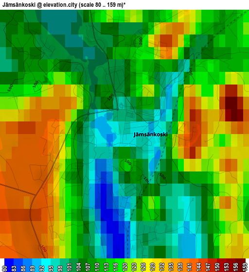
Below is the Elevation map of Jämsänkoski, which displays elevation range with different colors. Scale of the first map is from 80 to 159 m (262 to 522 ft) with average elevation of 115.1 meters (=378 ft) [note 1]
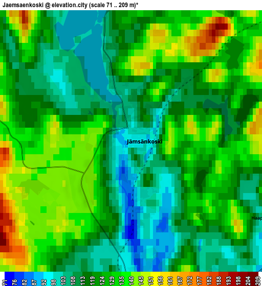
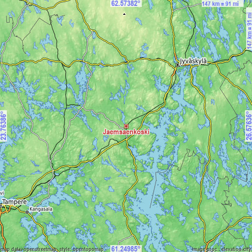
These maps also provides idea of topography and contour of this city, they are displayed at different zoom levels. More info about maps, scale and edge coordinates you can find below images.
| \ | Map #1 | Map #2 | Topo.Map |
| Scale [m] | 80..159 m | 71..209 m | × |
| Scale [ft] | 262..522 ft | 233..686 ft | × |
| Average | 115.1 m = 378 ft | 123.5 m = 405 ft | × |
| Width | 4.6 km = 2.9 mi | 9.2 km = 5.7 mi | 147.2 km = 91.5 mi |
| Height | 4.6 km = 2.9 mi | 9.2 km = 5.7 mi | 147.2 km = 91.5 mi |
| ↑Max Latitude | 61.939679° | 61.960344° | 62.57382° |
| Latitude at center | 61.919° | 61.919° | 61.919° |
| ↓Min Latitude | 61.898307° | 61.8776° | 61.24985° |
| ← Min Longitude | 25.126165° | 25.082219° | 23.76386° |
| Longitude center | 25.17011° | 25.17011° | 25.17011° |
| →Max Longitude | 25.214055° | 25.258001° | 26.57636° |
Nearby cities:
Cities around Jämsänkoski sort by population:
• Jyväskylä elevation 109 m
45.9 km,  38°
38°
• Jämsä 83 m
6.2 km,  170°
170°
• Keuruu 118 m
45.7 km,  327°
327°
• Muurame 81 m
35.2 km,  47°
47°
• Mänttä 104 m
30.9 km,  293°
293°
• Vilppula 113 m
36.6 km, 288°
• Korpilahti 109 m
22.6 km,  61°
61°
• Petäjävesi 138 m
36.8 km,  2°
2°
• Säynätsalo 75 m
39.8 km, 51°
• Kuhmoinen 108 m
39.2 km,  178°
178°
• Juupajoki 141 m
44.1 km,  252°
252°
• Luhanka 74 m
31.1 km,  115°
115°
Multilingual:
 En español:
Jämsänkoski elevación 97 m.
 En France:
Jämsänkoski élévation 97 m.
 Auf Deutsch:
Jämsänkoski höhe über dem Meeresspiegel ist 97 m.

Sources and notes:
- [note 1] Map square and city borders are not equal. Map elevation data is calculated only from area inside that square.
- [src 1] Elevation data from geonames database provided with same terms of usage.
- [src 2] The elevation map of Jämsänkoski is generated using GMTED2010 database with 7.5 arcsec (225m) resolution.
- [src 3] Base (background) map © OpenStreetMap contributors tiles are generated by Geofabrik and OpenTopoMap.
Copyright & License:
This Jämsänkoski Elevation Map is licensed under CC BY-SA. You may reuse any part from this page, if you give a proper credit by linking to this URL:
 More info on terms of use page.