Abomsa elevation
Abomsa (Amhara), Ethiopia elevation is 1300 meters and Abomsa elevation in feet is 4265 ft above sea level [src 1]. Abomsa is a populated place (feature code) with elevation that is 596 meters (1955 ft) smaller than average city elevation in Ethiopia.
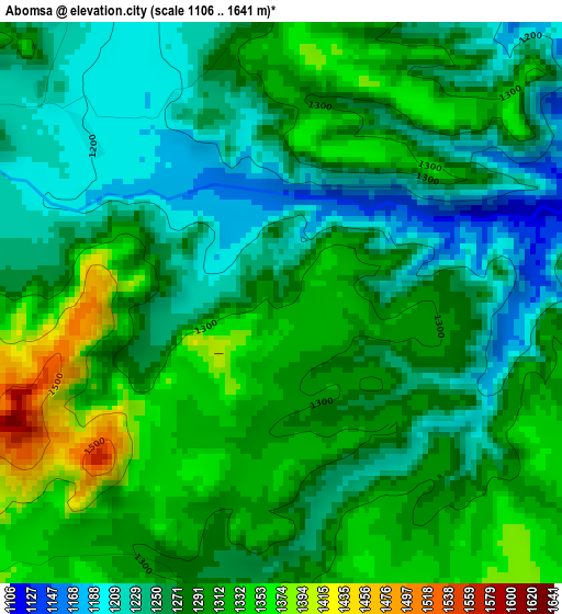
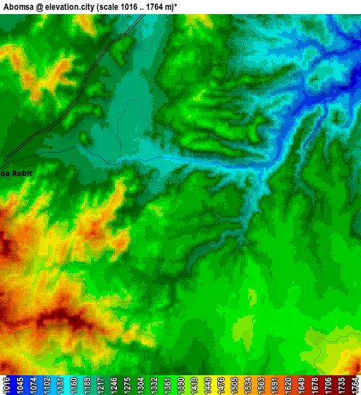
Below is the Elevation map of Abomsa, which displays elevation range with different colors. Scale of the first map is from 1106 to 1641 m (3629 to 5384 ft) with average elevation of 1283.8 meters (=4212 ft) [note 1]
These maps also provides idea of topography and contour of this city, they are displayed at different zoom levels. More info about maps, scale and edge coordinates you can find below images.
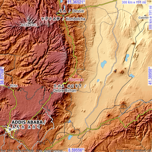
| \ | Map #1 | Map #2 | Topo.Map |
| Scale [m] | 1106..1641 m | 1016..1764 m | × |
| Scale [ft] | 3629..5384 ft | 3333..5787 ft | × |
| Average | 1283.8 m = 4212 ft | 1314.7 m = 4313 ft | × |
| Width | 9.62 km = 6 mi | 19.25 km = 12 mi | 308 km = 191.4 mi |
| Height | 9.62 km = 6 mi | 19.25 km = 12 mi | 308 km = 191.4 mi |
| ↑Max Latitude | 10.026607° | 10.069878° | 11.36521° |
| Latitude at center | 9.98333° | 9.98333° | 9.98333° |
| ↓Min Latitude | 9.940047° | 9.896759° | 8.59556° |
| ← Min Longitude | 39.939385° | 39.895439° | 38.57708° |
| Longitude center | 39.98333° | 39.98333° | 39.98333° |
| →Max Longitude | 40.027275° | 40.071221° | 41.38958° |
Nearby cities:
Cities around Abomsa sort by population:
• Desē elevation 2494 m
133.5 km,  343°
343°
• Kombolcha 1883 m
124.9 km,  347°
347°
• Debre Birhan 2830 m
59.8 km,  235°
235°
• Āsbe Teferī 1750 m
139.1 km,  135°
135°
• Fichē 2792 m
138.4 km,  261°
261°
• Kemisē 1438 m
82.5 km, 351°
• Metahāra 958 m
120.7 km,  183°
183°
• Batī 1662 m
134.4 km,  1°
1°
• Āwash 917 m
113 km,  169°
169°
• Gewanē 620 m
75.4 km,  74°
74°
• Debre Sīna 2703 m
28.7 km, 238°
• Were Īlu 2699 m
90 km,  318°
318°
Multilingual:
 En español:
Abomsa elevación 1300 m.
 En France:
Abomsa élévation 1300 m.


Sources and notes:
- [note 1] Map square and city borders are not equal. Map elevation data is calculated only from area inside that square.
- [src 1] Elevation data from geonames database provided with same terms of usage.
- [src 2] The elevation map of Abomsa is generated using elevation data from NASA's 3 arcsec (90m) resolution SRTM data.
- [src 3] Base (background) map © OpenStreetMap contributors tiles are generated by Geofabrik and OpenTopoMap.
Copyright & License:
This Abomsa Elevation Map is licensed under CC BY-SA. You may reuse any part from this page, if you give a proper credit by linking to this URL:
 More info on terms of use page.