Gewanē elevation
Gewanē (Āfar), Ethiopia elevation is 620 meters and Gewanē elevation in feet is 2034 ft above sea level [src 1]. Gewanē is a populated place (feature code) with elevation that is 1276 meters (4186 ft) smaller than average city elevation in Ethiopia.
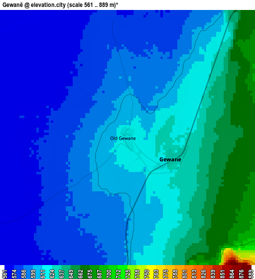
Below is the Elevation map of Gewanē, which displays elevation range with different colors. Scale of the first map is from 561 to 889 m (1841 to 2917 ft) with average elevation of 605.5 meters (=1987 ft) [note 1]
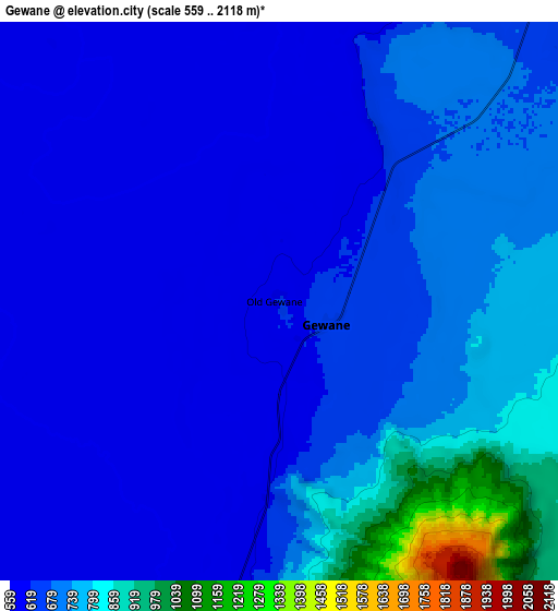
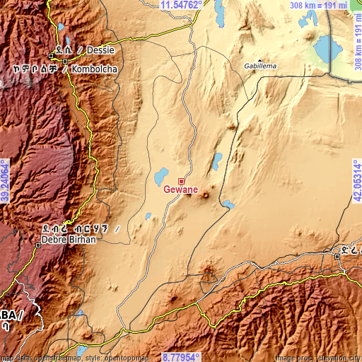
These maps also provides idea of topography and contour of this city, they are displayed at different zoom levels. More info about maps, scale and edge coordinates you can find below images.
| \ | Map #1 | Map #2 | Topo.Map |
| Scale [m] | 561..889 m | 559..2118 m | × |
| Scale [ft] | 1841..2917 ft | 1834..6949 ft | × |
| Average | 605.5 m = 1987 ft | 670.5 m = 2200 ft | × |
| Width | 9.62 km = 6 mi | 19.24 km = 12 mi | 307.8 km = 191.3 mi |
| Height | 9.62 km = 6 mi | 19.24 km = 12 mi | 307.8 km = 191.3 mi |
| ↑Max Latitude | 10.209832° | 10.253079° | 11.54762° |
| Latitude at center | 10.16658° | 10.16658° | 10.16658° |
| ↓Min Latitude | 10.123322° | 10.080058° | 8.77954° |
| ← Min Longitude | 40.602945° | 40.558999° | 39.24064° |
| Longitude center | 40.64689° | 40.64689° | 40.64689° |
| →Max Longitude | 40.690835° | 40.734781° | 42.05314° |
Nearby cities:
Cities around Gewanē sort by population:
• Kombolcha elevation 1883 m
141.8 km,  315°
315°
• Debre Birhan 2830 m
133.5 km,  246°
246°
• Āsbe Teferī 1750 m
122.6 km,  168°
168°
• Kemisē 1438 m
104.7 km,  305°
305°
• Batī 1662 m
133.1 km,  328°
328°
• Bedēsa 1683 m
141.6 km, 173°
• Abomsa 1300 m
75.4 km, 254°
• Hīrna 1789 m
116.7 km,  154°
154°
• Āwash 917 m
141.7 km,  201°
201°
• Debre Sīna 2703 m
103.4 km, 249°
• Deder 2330 m
129 km,  137°
137°
• Were Īlu 2699 m
140.4 km,  289°
289°
Multilingual:
 En español:
Gewanē elevación 620 m.
 En France:
Gewanē élévation 620 m.


Sources and notes:
- [note 1] Map square and city borders are not equal. Map elevation data is calculated only from area inside that square.
- [src 1] Elevation data from geonames database provided with same terms of usage.
- [src 2] The elevation map of Gewanē is generated using elevation data from NASA's 3 arcsec (90m) resolution SRTM data.
- [src 3] Base (background) map © OpenStreetMap contributors tiles are generated by Geofabrik and OpenTopoMap.
Copyright & License:
This Gewanē Elevation Map is licensed under CC BY-SA. You may reuse any part from this page, if you give a proper credit by linking to this URL:
 More info on terms of use page.