Jijiga elevation
Jijiga (Somali), Ethiopia elevation is 1646 meters and Jijiga elevation in feet is 5400 ft above sea level [src 1]. Jijiga is a seat of a first-order administrative division (feature code) with elevation that is 250 meters (820 ft) smaller than average city elevation in Ethiopia.
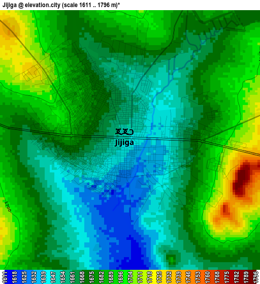
Below is the Elevation map of Jijiga, which displays elevation range with different colors. Scale of the first map is from 1611 to 1796 m (5285 to 5892 ft) with average elevation of 1673.6 meters (=5491 ft) [note 1]
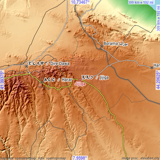
These maps also provides idea of topography and contour of this city, they are displayed at different zoom levels. More info about maps, scale and edge coordinates you can find below images.
| \ | Map #1 | Map #2 | Topo.Map |
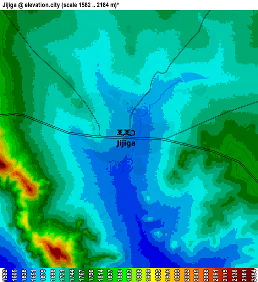
| Scale [m] | 1611..1796 m | 1582..2184 m | × |
| Scale [ft] | 5285..5892 ft | 5190..7165 ft | × |
| Average | 1673.6 m = 5491 ft | 1719.3 m = 5641 ft | × |
| Width | 9.64 km = 6 mi | 19.29 km = 12 mi | 308.5 km = 191.7 mi |
| Height | 9.64 km = 6 mi | 19.29 km = 12 mi | 308.6 km = 191.8 mi |
| ↑Max Latitude | 9.393359° | 9.436712° | 10.73467° |
| Latitude at center | 9.35° | 9.35° | 9.35° |
| ↓Min Latitude | 9.306636° | 9.263266° | 7.9598° |
| ← Min Longitude | 42.756055° | 42.712109° | 41.39375° |
| Longitude center | 42.8° | 42.8° | 42.8° |
| →Max Longitude | 42.843945° | 42.887891° | 44.20625° |
Nearby cities:
Cities around Jijiga sort by population:
• Dire Dawa elevation 1204 m
105.9 km,  284°
284°
• Harar 1917 m
74.9 km,  266°
266°
• Āsbe Teferī 1750 m
214.2 km,  262°
262°
• Metahāra 958 m
320.5 km, 261°
• Asaita 371 m
288.1 km,  328°
328°
• Bedēsa 1683 m
227 km, 257°
• Gelemso 1795 m
257.6 km, 256°
• Abomsa 1300 m
316.7 km, 282°
• Hīrna 1789 m
187.1 km, 265°
• Āwash 917 m
291.9 km, 261°
• Gewanē 620 m
252.8 km,  291°
291°
• Deder 2330 m
148.9 km, 268°
Multilingual:
 En español:
Jijiga elevación 1646 m.
 En France:
Djidjiga élévation 1646 m.


Sources and notes:
- [note 1] Map square and city borders are not equal. Map elevation data is calculated only from area inside that square.
- [src 1] Elevation data from geonames database provided with same terms of usage.
- [src 2] The elevation map of Jijiga is generated using elevation data from NASA's 3 arcsec (90m) resolution SRTM data.
- [src 3] Base (background) map © OpenStreetMap contributors tiles are generated by Geofabrik and OpenTopoMap.
Copyright & License:
This Jijiga Elevation Map is licensed under CC BY-SA. You may reuse any part from this page, if you give a proper credit by linking to this URL:
 More info on terms of use page.