Forcarei elevation
Forcarei (Galicia, Provincia de Pontevedra), Spain elevation is 594 meters and Forcarei elevation in feet is 1949 ft above sea level [src 1]. Forcarei is a seat of a third-order administrative division (feature code) with elevation that is 9 meters (30 ft) smaller than average city elevation in Spain.
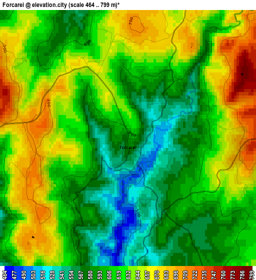
Below is the Elevation map of Forcarei, which displays elevation range with different colors. Scale of the first map is from 464 to 799 m (1522 to 2621 ft) with average elevation of 618.2 meters (=2028 ft) [note 1]
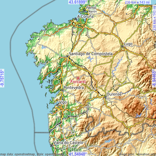
These maps also provides idea of topography and contour of this city, they are displayed at different zoom levels. More info about maps, scale and edge coordinates you can find below images.
| \ | Map #1 | Topo.Map |
| Scale [m] | 464..799 m | × |
| Scale [ft] | 1522..2621 ft | × |
| Average | 618.2 m = 2028 ft | × |
| Width | 7.19 km = 4.5 mi | 230.2 km = 143 mi |
| Height | 7.19 km = 4.5 mi | 230.2 km = 143 mi |
| ↑Max Latitude | 42.624674° | 43.61899° |
| Latitude at center | 42.59233° | 42.59233° |
| ↓Min Latitude | 42.55997° | 41.54848° |
| ← Min Longitude | -8.394845° | -9.75715° |
| Longitude center | -8.3509° | -8.3509° |
| →Max Longitude | -8.306955° | -6.94465° |
Nearby cities:
Cities around Forcarei sort by population:
• Ribeira elevation 64 m
18.7 km,  336°
336°
• A Estrada 301 m
15.6 km,  313°
313°
• Lalín 552 m
20.9 km,  68°
68°
• Teo 170 m
21.4 km,  325°
325°
• Caldas de Reis 38 m
23.9 km,  273°
273°
• Silleda 494 m
14.3 km,  36°
36°
• Cuntis 164 m
17.9 km,  284°
284°
• Vedra 192 m
23.1 km, 333°
• Moraña 212 m
19.6 km,  256°
256°
• Boborás 429 m
24.5 km,  136°
136°
• Lama 493 m
22.4 km,  197°
197°
• Barro 157 m
22.6 km, 259°
Multilingual:
 En español:
Forcarei elevación 594 m.
 En France:
Forcarei élévation 594 m.
 Auf Deutsch:
Forcarei höhe über dem Meeresspiegel ist 594 m.

Sources and notes:
- [note 1] Map square and city borders are not equal. Map elevation data is calculated only from area inside that square.
- [src 1] Elevation data from geonames database provided with same terms of usage.
- [src 2] The elevation map of Forcarei is generated using elevation data from NASA's 3 arcsec (90m) resolution SRTM data.
- [src 3] Base (background) map © OpenStreetMap contributors tiles are generated by Geofabrik and OpenTopoMap.
Copyright & License:
This Forcarei Elevation Map is licensed under CC BY-SA. You may reuse any part from this page, if you give a proper credit by linking to this URL:
 More info on terms of use page.