Cuntis elevation
Cuntis (Galicia, Provincia de Pontevedra), Spain elevation is 164 meters and Cuntis elevation in feet is 538 ft above sea level [src 1]. Cuntis is a seat of a third-order administrative division (feature code) with elevation that is 439 meters (1440 ft) smaller than average city elevation in Spain.
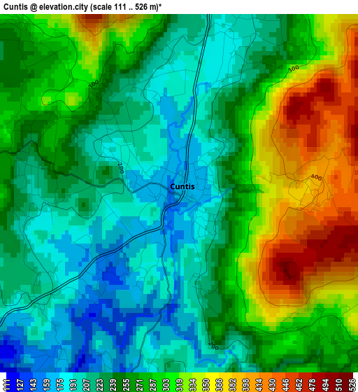
Below is the Elevation map of Cuntis, which displays elevation range with different colors. Scale of the first map is from 111 to 526 m (364 to 1726 ft) with average elevation of 261.2 meters (=857 ft) [note 1]
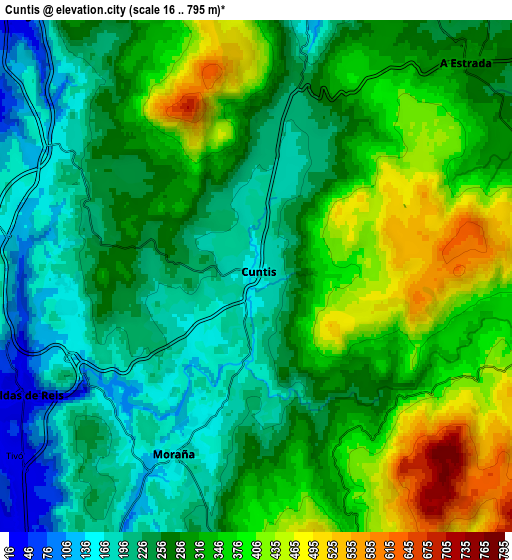
These maps also provides idea of topography and contour of this city, they are displayed at different zoom levels. More info about maps, scale and edge coordinates you can find below images.
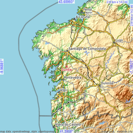
| \ | Map #1 | Map #2 | Topo.Map |
| Scale [m] | 111..526 m | 16..795 m | × |
| Scale [ft] | 364..1726 ft | 52..2608 ft | × |
| Average | 261.2 m = 857 ft | 295.8 m = 970 ft | × |
| Width | 7.19 km = 4.5 mi | 14.38 km = 8.9 mi | 230.1 km = 143 mi |
| Height | 7.19 km = 4.5 mi | 14.38 km = 8.9 mi | 230.1 km = 143 mi |
| ↑Max Latitude | 42.666282° | 42.698587° | 43.65993° |
| Latitude at center | 42.63396° | 42.63396° | 42.63396° |
| ↓Min Latitude | 42.601621° | 42.569266° | 41.5908° |
| ← Min Longitude | -8.606505° | -8.650451° | -9.96881° |
| Longitude center | -8.56256° | -8.56256° | -8.56256° |
| →Max Longitude | -8.518615° | -8.474669° | -7.15631° |
Nearby cities:
Cities around Cuntis sort by population:
• Vilagarcía de Arousa elevation 10 m
17 km,  255°
255°
• Ribeira 64 m
15.8 km,  37°
37°
• A Estrada 301 m
8.6 km, 44°
• Teo 170 m
13.9 km,  21°
21°
• Caldas de Reis 38 m
7.3 km,  243°
243°
• Padrón 13 m
14.1 km,  325°
325°
• Valga 75 m
9.5 km,  318°
318°
• Vedra 192 m
17.5 km, 23°
• Moraña 212 m
9.5 km,  190°
190°
• Catoira 16 m
13.7 km,  285°
285°
• Portas 23 m
9.3 km,  234°
234°
• Barro 157 m
10 km,  209°
209°
Multilingual:
 En español:
Cuntis elevación 164 m.
 En France:
Cuntis élévation 164 m.


Sources and notes:
- [note 1] Map square and city borders are not equal. Map elevation data is calculated only from area inside that square.
- [src 1] Elevation data from geonames database provided with same terms of usage.
- [src 2] The elevation map of Cuntis is generated using elevation data from NASA's 3 arcsec (90m) resolution SRTM data.
- [src 3] Base (background) map © OpenStreetMap contributors tiles are generated by Geofabrik and OpenTopoMap.
Copyright & License:
This Cuntis Elevation Map is licensed under CC BY-SA. You may reuse any part from this page, if you give a proper credit by linking to this URL:
 More info on terms of use page.