Lalín elevation
Lalín (Galicia, Provincia de Pontevedra), Spain elevation is 552 meters and Lalín elevation in feet is 1811 ft above sea level [src 1]. Lalín is a populated place (feature code) with elevation that is 51 meters (167 ft) smaller than average city elevation in Spain.
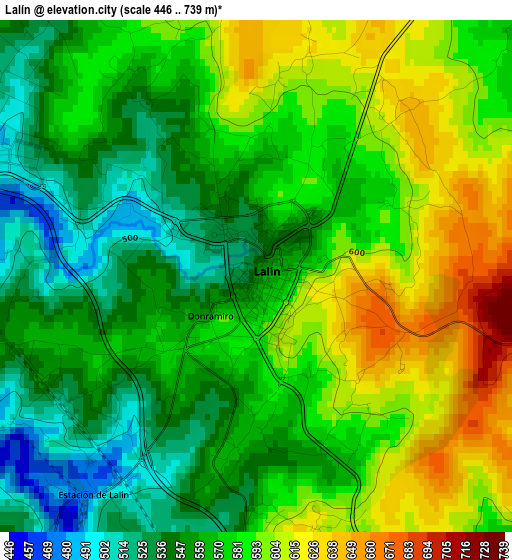
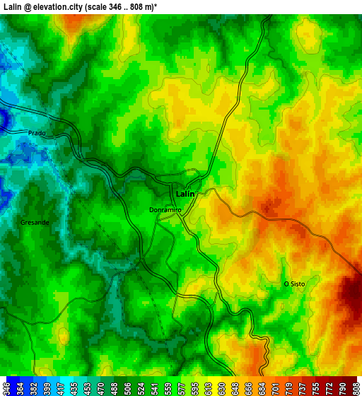
Below is the Elevation map of Lalín, which displays elevation range with different colors. Scale of the first map is from 446 to 739 m (1463 to 2425 ft) with average elevation of 574.8 meters (=1886 ft) [note 1]
These maps also provides idea of topography and contour of this city, they are displayed at different zoom levels. More info about maps, scale and edge coordinates you can find below images.
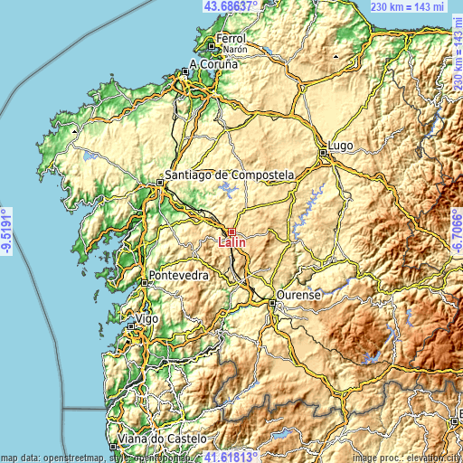
| \ | Map #1 | Map #2 | Topo.Map |
| Scale [m] | 446..739 m | 346..808 m | × |
| Scale [ft] | 1463..2425 ft | 1135..2651 ft | × |
| Average | 574.8 m = 1886 ft | 567.4 m = 1862 ft | × |
| Width | 7.19 km = 4.5 mi | 14.37 km = 8.9 mi | 230 km = 142.9 mi |
| Height | 7.19 km = 4.5 mi | 14.37 km = 8.9 mi | 230 km = 142.9 mi |
| ↑Max Latitude | 42.693158° | 42.725449° | 43.68637° |
| Latitude at center | 42.66085° | 42.66085° | 42.66085° |
| ↓Min Latitude | 42.628525° | 42.596184° | 41.61813° |
| ← Min Longitude | -8.156795° | -8.200741° | -9.5191° |
| Longitude center | -8.11285° | -8.11285° | -8.11285° |
| →Max Longitude | -8.068905° | -8.024959° | -6.7066° |
Nearby cities:
Cities around Lalín sort by population:
• O Carballiño elevation 402 m
25.6 km,  173°
173°
• Silleda 494 m
11.6 km,  289°
289°
• Monterroso 549 m
27.1 km,  57°
57°
• Taboada 623 m
24.1 km,  79°
79°
• Rodeiro 656 m
12.9 km,  94°
94°
• Boborás 429 m
25.4 km,  185°
185°
• Cea 518 m
23.1 km,  153°
153°
• Dozón 722 m
11.7 km,  137°
137°
• Carballedo 575 m
27.9 km,  123°
123°
• Santiso 373 m
24.2 km,  11°
11°
• Forcarei 594 m
20.9 km,  248°
248°
• Piñor 547 m
20 km, 152°
Multilingual:
 En español:
Lalín elevación 552 m.
 En France:
Lalín élévation 552 m.


Sources and notes:
- [note 1] Map square and city borders are not equal. Map elevation data is calculated only from area inside that square.
- [src 1] Elevation data from geonames database provided with same terms of usage.
- [src 2] The elevation map of Lalín is generated using elevation data from NASA's 3 arcsec (90m) resolution SRTM data.
- [src 3] Base (background) map © OpenStreetMap contributors tiles are generated by Geofabrik and OpenTopoMap.
Copyright & License:
This Lalín Elevation Map is licensed under CC BY-SA. You may reuse any part from this page, if you give a proper credit by linking to this URL:
 More info on terms of use page.