Coma-ruga elevation
Coma-ruga (Catalonia, Província de Tarragona), Spain elevation is 2 meters and Coma-ruga elevation in feet is 7 ft above sea level [src 1]. Coma-ruga is a populated place (feature code) with elevation that is 601 meters (1972 ft) smaller than average city elevation in Spain.
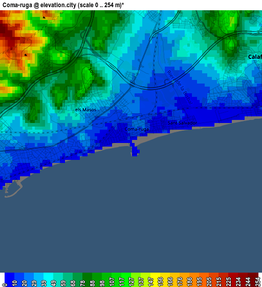
Below is the Elevation map of Coma-ruga, which displays elevation range with different colors. Scale of the first map is from 0 to 254 m (0 to 833 ft) with average elevation of 55.6 meters (=182 ft) [note 1]
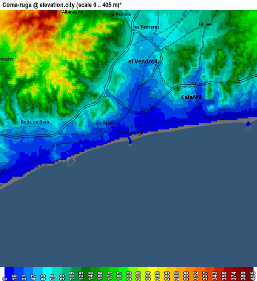
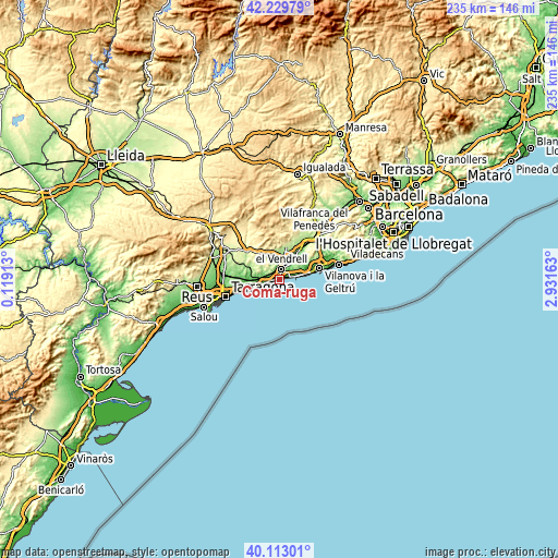
These maps also provides idea of topography and contour of this city, they are displayed at different zoom levels. More info about maps, scale and edge coordinates you can find below images.
| \ | Map #1 | Map #2 | Topo.Map |
| Scale [m] | 0..254 m | 0..405 m | × |
| Scale [ft] | 0..833 ft | 0..1329 ft | × |
| Average | 55.6 m = 182 ft | 110.2 m = 362 ft | × |
| Width | 7.36 km = 4.6 mi | 14.71 km = 9.1 mi | 235.4 km = 146.3 mi |
| Height | 7.36 km = 4.6 mi | 14.71 km = 9.1 mi | 235.4 km = 146.3 mi |
| ↑Max Latitude | 41.213017° | 41.246067° | 42.22979° |
| Latitude at center | 41.17995° | 41.17995° | 41.17995° |
| ↓Min Latitude | 41.146866° | 41.113766° | 40.11301° |
| ← Min Longitude | 1.481435° | 1.437489° | 0.11913° |
| Longitude center | 1.52538° | 1.52538° | 1.52538° |
| →Max Longitude | 1.569325° | 1.613271° | 2.93163° |
Nearby cities:
Cities around Coma-ruga sort by population:
• El Vendrell elevation 41 m
4.1 km,  9°
9°
• Calafell 46 m
4.2 km,  58°
58°
• Torredembarra 26 m
11.3 km,  249°
249°
• Cubelles 13 m
12.7 km,  75°
75°
• Cunit 12 m
9.5 km, 77°
• Castellet 114 m
12.9 km,  44°
44°
• Roda de Barà 60 m
5.6 km,  277°
277°
• Santa Oliva 103 m
8.5 km, 14°
• Creixell 35 m
7.3 km,  257°
257°
• Bonastre 173 m
8.5 km,  301°
301°
• la Bisbal del Penedès 189 m
12 km,  342°
342°
• Albinyana 216 m
8.5 km, 335°
Multilingual:
 En español:
Comarruga elevación 2 m.
 En France:
Coma-ruga élévation 2 m.


Sources and notes:
- [note 1] Map square and city borders are not equal. Map elevation data is calculated only from area inside that square.
- [src 1] Elevation data from geonames database provided with same terms of usage.
- [src 2] The elevation map of Coma-ruga is generated using elevation data from NASA's 3 arcsec (90m) resolution SRTM data.
- [src 3] Base (background) map © OpenStreetMap contributors tiles are generated by Geofabrik and OpenTopoMap.
Copyright & License:
This Coma-ruga Elevation Map is licensed under CC BY-SA. You may reuse any part from this page, if you give a proper credit by linking to this URL:
 More info on terms of use page.