Bonastre elevation
Bonastre (Catalonia, Província de Tarragona), Spain elevation is 173 meters and Bonastre elevation in feet is 568 ft above sea level [src 1]. Bonastre is a seat of a third-order administrative division (feature code) with elevation that is 430 meters (1411 ft) smaller than average city elevation in Spain.
Below is the Elevation map of Bonastre, which displays elevation range with different colors. Scale of the first map is from 53 to 405 m (174 to 1329 ft) with average elevation of 217.4 meters (=713 ft) [note 1]
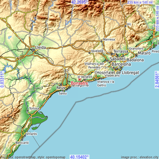
These maps also provides idea of topography and contour of this city, they are displayed at different zoom levels. More info about maps, scale and edge coordinates you can find below images.
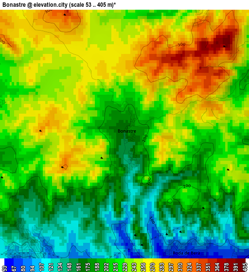
| \ | Map #1 | Topo.Map |
| Scale [m] | 53..405 m | × |
| Scale [ft] | 174..1329 ft | × |
| Average | 217.4 m = 713 ft | × |
| Width | 7.35 km = 4.6 mi | 235.2 km = 146.1 mi |
| Height | 7.35 km = 4.6 mi | 235.2 km = 146.1 mi |
| ↑Max Latitude | 41.253356° | 42.2695° |
| Latitude at center | 41.22031° | 41.22031° |
| ↓Min Latitude | 41.187247° | 40.15402° |
| ← Min Longitude | 1.395415° | 0.03311° |
| Longitude center | 1.43936° | 1.43936° |
| →Max Longitude | 1.483305° | 2.84561° |
Nearby cities:
Cities around Bonastre sort by population:
• El Vendrell elevation 41 m
7.9 km,  92°
92°
• Torredembarra 26 m
9 km,  202°
202°
• Roda de Barà 60 m
4.1 km,  156°
156°
• Coma-ruga 2 m
8.5 km,  121°
121°
• Altafulla 37 m
10.3 km,  212°
212°
• Santa Oliva 103 m
10 km,  68°
68°
• Creixell 35 m
6 km,  179°
179°
• Vilabella 260 m
9.6 km,  288°
288°
• Salomó 164 m
5.5 km,  280°
280°
• Montferri 226 m
8 km,  308°
308°
• la Bisbal del Penedès 189 m
7.9 km,  27°
27°
• Albinyana 216 m
4.9 km,  48°
48°
Multilingual:
 En español:
Bonastre elevación 173 m.
 En France:
Bonastre élévation 173 m.
 Auf Deutsch:
Bonastre höhe über dem Meeresspiegel ist 173 m.

Sources and notes:
- [note 1] Map square and city borders are not equal. Map elevation data is calculated only from area inside that square.
- [src 1] Elevation data from geonames database provided with same terms of usage.
- [src 2] The elevation map of Bonastre is generated using elevation data from NASA's 3 arcsec (90m) resolution SRTM data.
- [src 3] Base (background) map © OpenStreetMap contributors tiles are generated by Geofabrik and OpenTopoMap.
Copyright & License:
This Bonastre Elevation Map is licensed under CC BY-SA. You may reuse any part from this page, if you give a proper credit by linking to this URL:
 More info on terms of use page.