Adzaneta elevation
Adzaneta (Valencia, Província de Castelló), Spain elevation is 403 meters and Adzaneta elevation in feet is 1322 ft above sea level [src 1]. Adzaneta is a populated place (feature code) with elevation that is 200 meters (656 ft) smaller than average city elevation in Spain.
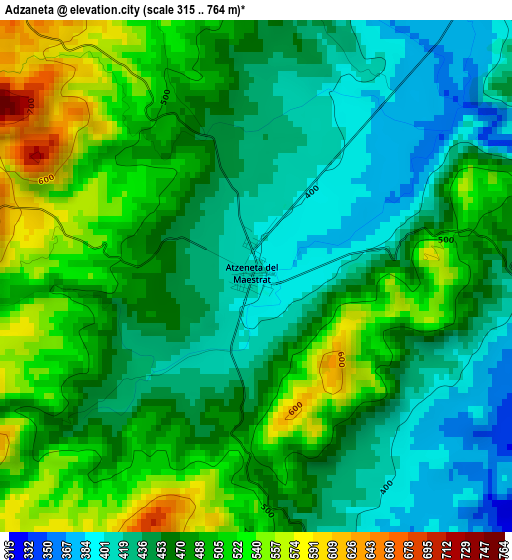
Below is the Elevation map of Adzaneta, which displays elevation range with different colors. Scale of the first map is from 315 to 764 m (1033 to 2507 ft) with average elevation of 471.3 meters (=1546 ft) [note 1]
These maps also provides idea of topography and contour of this city, they are displayed at different zoom levels. More info about maps, scale and edge coordinates you can find below images.
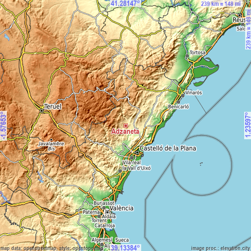
| \ | Map #1 | Topo.Map |
| Scale [m] | 315..764 m | × |
| Scale [ft] | 1033..2507 ft | × |
| Average | 471.3 m = 1546 ft | × |
| Width | 7.46 km = 4.6 mi | 238.8 km = 148.4 mi |
| Height | 7.46 km = 4.6 mi | 238.8 km = 148.4 mi |
| ↑Max Latitude | 40.249709° | 41.28147° |
| Latitude at center | 40.21616° | 40.21616° |
| ↓Min Latitude | 40.182594° | 39.13384° |
| ← Min Longitude | -0.214225° | -1.57653° |
| Longitude center | -0.17028° | -0.17028° |
| →Max Longitude | -0.126335° | 1.23597° |
Nearby cities:
Cities around Adzaneta sort by population:
• l'Alcora elevation 236 m
16.8 km,  188°
188°
• San Juan de Moró 192 m
17.6 km,  170°
170°
• Villafamés 284 m
15.1 km,  137°
137°
• Lucena del Cid 623 m
13.3 km,  226°
226°
• Benassal 845 m
18.1 km,  8°
8°
• Sierra-Engarcerán 752 m
14.1 km,  65°
65°
• Benlloch 317 m
16.8 km,  92°
92°
• Culla 1065 m
13.4 km,  1°
1°
• Figueroles 360 m
12.3 km,  205°
205°
• Costur 472 m
10.7 km,  181°
181°
• Vistabella del Maestrazgo 1219 m
13.8 km,  310°
310°
• Benafigos 918 m
7.4 km,  334°
334°
Multilingual:
 En español:
Adzaneta elevación 403 m.
 En France:
Adzaneta élévation 403 m.
 Auf Deutsch:
Adzaneta höhe über dem Meeresspiegel ist 403 m.

Sources and notes:
- [note 1] Map square and city borders are not equal. Map elevation data is calculated only from area inside that square.
- [src 1] Elevation data from geonames database provided with same terms of usage.
- [src 2] The elevation map of Adzaneta is generated using elevation data from NASA's 3 arcsec (90m) resolution SRTM data.
- [src 3] Base (background) map © OpenStreetMap contributors tiles are generated by Geofabrik and OpenTopoMap.
Copyright & License:
This Adzaneta Elevation Map is licensed under CC BY-SA. You may reuse any part from this page, if you give a proper credit by linking to this URL:
 More info on terms of use page.