Sierra-Engarcerán elevation
Sierra-Engarcerán (Valencia, Província de Castelló), Spain elevation is 752 meters and Sierra-Engarcerán elevation in feet is 2467 ft above sea level [src 1]. Sierra-Engarcerán is a populated place (feature code) with elevation that is 149 meters (489 ft) bigger than average city elevation in Spain.
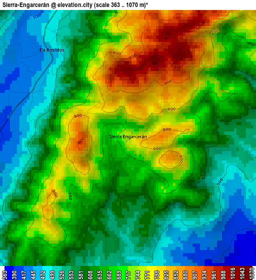
Below is the Elevation map of Sierra-Engarcerán, which displays elevation range with different colors. Scale of the first map is from 363 to 1070 m (1191 to 3510 ft) with average elevation of 645.4 meters (=2117 ft) [note 1]
These maps also provides idea of topography and contour of this city, they are displayed at different zoom levels. More info about maps, scale and edge coordinates you can find below images.
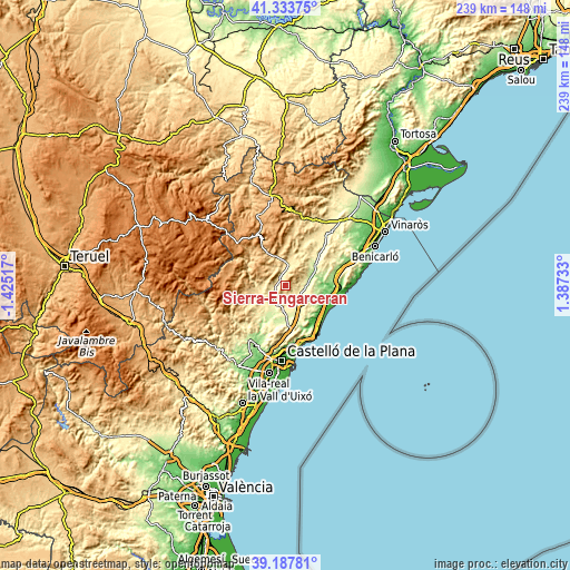
| \ | Map #1 | Topo.Map |
| Scale [m] | 363..1070 m | × |
| Scale [ft] | 1191..3510 ft | × |
| Average | 645.4 m = 2117 ft | × |
| Width | 7.46 km = 4.6 mi | 238.6 km = 148.3 mi |
| Height | 7.46 km = 4.6 mi | 238.6 km = 148.3 mi |
| ↑Max Latitude | 40.302813° | 41.33375° |
| Latitude at center | 40.26929° | 40.26929° |
| ↓Min Latitude | 40.235751° | 39.18781° |
| ← Min Longitude | -0.062865° | -1.42517° |
| Longitude center | -0.01892° | -0.01892° |
| →Max Longitude | 0.025025° | 1.38733° |
Nearby cities:
Cities around Sierra-Engarcerán sort by population:
• Torreblanca elevation 30 m
19.1 km,  106°
106°
• Cabanes 276 m
13.7 km,  157°
157°
• Cuevas de Vinromá 189 m
12.7 km,  69°
69°
• Villafamés 284 m
17.2 km,  188°
188°
• Adzaneta 403 m
14.1 km,  245°
245°
• Albocàsser 564 m
10 km,  26°
26°
• Benassal 845 m
15.7 km,  319°
319°
• Benlloch 317 m
7.6 km,  148°
148°
• Culla 1065 m
14.5 km,  300°
300°
• Costur 472 m
21.2 km,  218°
218°
• Benafigos 918 m
16 km,  272°
272°
• Sarratella 774 m
6.5 km,  41°
41°
Multilingual:
 En español:
Sierra-Engarcerán elevación 752 m.
 En France:
Sierra-Engarcerán élévation 752 m.
 Auf Deutsch:
Sierra-Engarcerán höhe über dem Meeresspiegel ist 752 m.

Sources and notes:
- [note 1] Map square and city borders are not equal. Map elevation data is calculated only from area inside that square.
- [src 1] Elevation data from geonames database provided with same terms of usage.
- [src 2] The elevation map of Sierra-Engarcerán is generated using elevation data from NASA's 3 arcsec (90m) resolution SRTM data.
- [src 3] Base (background) map © OpenStreetMap contributors tiles are generated by Geofabrik and OpenTopoMap.
Copyright & License:
This Sierra-Engarcerán Elevation Map is licensed under CC BY-SA. You may reuse any part from this page, if you give a proper credit by linking to this URL:
 More info on terms of use page.