Alaraz elevation
Alaraz (Castille and León, Provincia de Salamanca), Spain elevation is 884 meters and Alaraz elevation in feet is 2900 ft above sea level [src 1]. Alaraz is a seat of a third-order administrative division (feature code) with elevation that is 281 meters (922 ft) bigger than average city elevation in Spain.
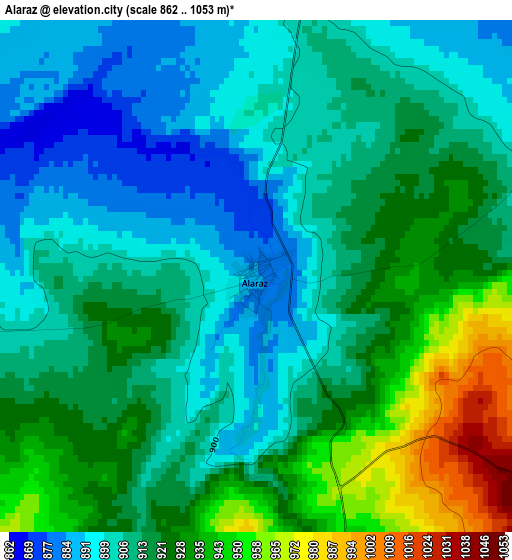
Below is the Elevation map of Alaraz, which displays elevation range with different colors. Scale of the first map is from 862 to 1053 m (2828 to 3455 ft) with average elevation of 915.4 meters (=3003 ft) [note 1]
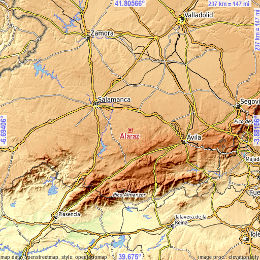
These maps also provides idea of topography and contour of this city, they are displayed at different zoom levels. More info about maps, scale and edge coordinates you can find below images.
| \ | Map #1 | Topo.Map |
| Scale [m] | 862..1053 m | × |
| Scale [ft] | 2828..3455 ft | × |
| Average | 915.4 m = 3003 ft | × |
| Width | 7.4 km = 4.6 mi | 236.9 km = 147.2 mi |
| Height | 7.4 km = 4.6 mi | 236.9 km = 147.2 mi |
| ↑Max Latitude | 40.782144° | 41.80566° |
| Latitude at center | 40.74886° | 40.74886° |
| ↓Min Latitude | 40.71556° | 39.675° |
| ← Min Longitude | -5.331755° | -6.69406° |
| Longitude center | -5.28781° | -5.28781° |
| →Max Longitude | -5.243865° | -3.88156° |
Nearby cities:
Cities around Alaraz sort by population:
• Macotera elevation 894 m
9.1 km,  1°
1°
• Santiago de la Puebla 872 m
5.9 km,  5°
5°
• Cabezas del Villar 1045 m
7.6 km,  119°
119°
• Valdecarros 886 m
11.6 km,  281°
281°
• Mancera de Abajo 895 m
12.6 km,  36°
36°
• Pedraza de Alba 898 m
7.4 km, 275°
• Salmoral 911 m
8.2 km, 44°
• Pedrosillo de Alba 837 m
12.2 km,  312°
312°
• Gajates 856 m
7.5 km,  299°
299°
• San Miguel de Serrezuela 1098 m
8.7 km,  180°
180°
• Malpartida 905 m
5 km,  72°
72°
• Pascualcobo 1072 m
10.3 km, 175°
Multilingual:
 En español:
Alaraz elevación 884 m.
 En France:
Alaraz élévation 884 m.


Sources and notes:
- [note 1] Map square and city borders are not equal. Map elevation data is calculated only from area inside that square.
- [src 1] Elevation data from geonames database provided with same terms of usage.
- [src 2] The elevation map of Alaraz is generated using elevation data from NASA's 3 arcsec (90m) resolution SRTM data.
- [src 3] Base (background) map © OpenStreetMap contributors tiles are generated by Geofabrik and OpenTopoMap.
Copyright & License:
This Alaraz Elevation Map is licensed under CC BY-SA. You may reuse any part from this page, if you give a proper credit by linking to this URL:
 More info on terms of use page.