Malpartida elevation
Malpartida (Castille and León, Provincia de Salamanca), Spain elevation is 905 meters and Malpartida elevation in feet is 2969 ft above sea level [src 1]. Malpartida is a seat of a third-order administrative division (feature code) with elevation that is 302 meters (991 ft) bigger than average city elevation in Spain.
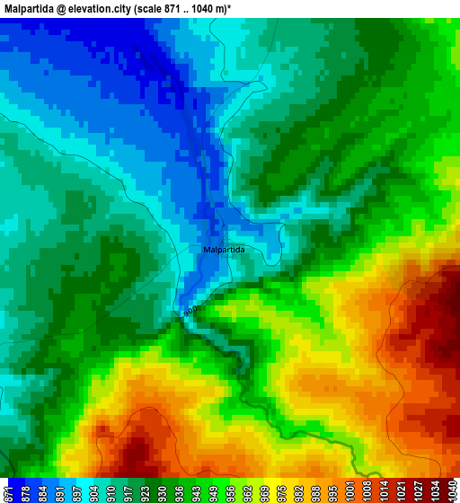
Below is the Elevation map of Malpartida, which displays elevation range with different colors. Scale of the first map is from 871 to 1040 m (2858 to 3412 ft) with average elevation of 935.6 meters (=3070 ft) [note 1]
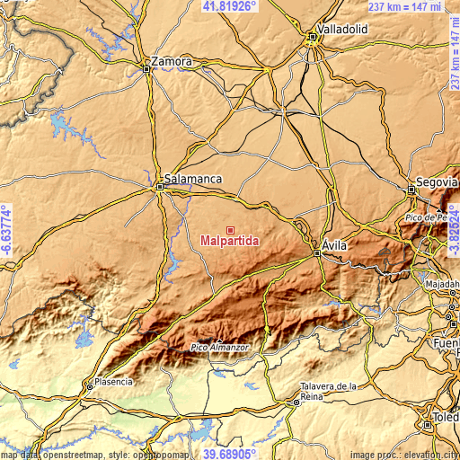
These maps also provides idea of topography and contour of this city, they are displayed at different zoom levels. More info about maps, scale and edge coordinates you can find below images.
| \ | Map #1 | Topo.Map |
| Scale [m] | 871..1040 m | × |
| Scale [ft] | 2858..3412 ft | × |
| Average | 935.6 m = 3070 ft | × |
| Width | 7.4 km = 4.6 mi | 236.9 km = 147.2 mi |
| Height | 7.4 km = 4.6 mi | 236.9 km = 147.2 mi |
| ↑Max Latitude | 40.795967° | 41.81926° |
| Latitude at center | 40.76269° | 40.76269° |
| ↓Min Latitude | 40.729397° | 39.68905° |
| ← Min Longitude | -5.275435° | -6.63774° |
| Longitude center | -5.23149° | -5.23149° |
| →Max Longitude | -5.187545° | -3.82524° |
Nearby cities:
Cities around Malpartida sort by population:
• Macotera elevation 894 m
8.8 km,  329°
329°
• Alaraz 884 m
5 km,  252°
252°
• Santiago de la Puebla 872 m
6 km,  316°
316°
• Cabezas del Villar 1045 m
5.6 km,  160°
160°
• Mancera de Abajo 895 m
9 km,  17°
17°
• Bóveda del Río Almar 883 m
10.7 km,  9°
9°
• Salmoral 911 m
4.4 km, 13°
• Gajates 856 m
11.5 km,  281°
281°
• San Miguel de Serrezuela 1098 m
11.3 km,  205°
205°
• San García de Ingelmos 1069 m
9.8 km,  85°
85°
• Mancera de Arriba 935 m
7.7 km,  65°
65°
• Gallegos de Sobrinos 1165 m
11.3 km,  116°
116°
Multilingual:
 En español:
Malpartida elevación 905 m.
 En France:
Malpartida élévation 905 m.
 Auf Deutsch:
Malpartida höhe über dem Meeresspiegel ist 905 m.

Sources and notes:
- [note 1] Map square and city borders are not equal. Map elevation data is calculated only from area inside that square.
- [src 1] Elevation data from geonames database provided with same terms of usage.
- [src 2] The elevation map of Malpartida is generated using elevation data from NASA's 3 arcsec (90m) resolution SRTM data.
- [src 3] Base (background) map © OpenStreetMap contributors tiles are generated by Geofabrik and OpenTopoMap.
Copyright & License:
This Malpartida Elevation Map is licensed under CC BY-SA. You may reuse any part from this page, if you give a proper credit by linking to this URL:
 More info on terms of use page.