Gajates elevation
Gajates (Castille and León, Provincia de Salamanca), Spain elevation is 856 meters and Gajates elevation in feet is 2808 ft above sea level [src 1]. Gajates is a seat of a third-order administrative division (feature code) with elevation that is 253 meters (830 ft) bigger than average city elevation in Spain.
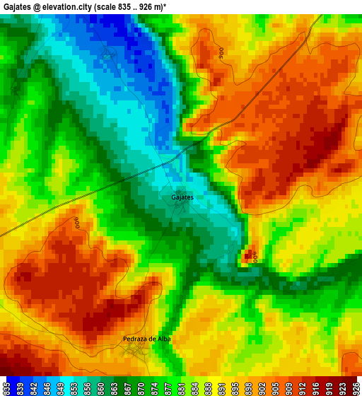
Below is the Elevation map of Gajates, which displays elevation range with different colors. Scale of the first map is from 835 to 926 m (2740 to 3038 ft) with average elevation of 884 meters (=2900 ft) [note 1]
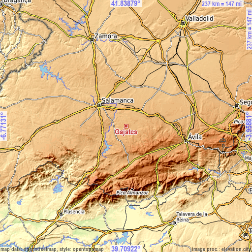
These maps also provides idea of topography and contour of this city, they are displayed at different zoom levels. More info about maps, scale and edge coordinates you can find below images.
| \ | Map #1 | Topo.Map |
| Scale [m] | 835..926 m | × |
| Scale [ft] | 2740..3038 ft | × |
| Average | 884 m = 2900 ft | × |
| Width | 7.4 km = 4.6 mi | 236.8 km = 147.1 mi |
| Height | 7.4 km = 4.6 mi | 236.8 km = 147.1 mi |
| ↑Max Latitude | 40.815807° | 41.83879° |
| Latitude at center | 40.78254° | 40.78254° |
| ↓Min Latitude | 40.749257° | 39.70922° |
| ← Min Longitude | -5.409005° | -6.77131° |
| Longitude center | -5.36506° | -5.36506° |
| →Max Longitude | -5.321115° | -3.95881° |
Nearby cities:
Cities around Gajates sort by population:
• Macotera elevation 894 m
8.6 km,  51°
51°
• Alaraz 884 m
7.5 km,  119°
119°
• Garcihernández 817 m
10.6 km,  325°
325°
• Tordillos 841 m
7.9 km,  7°
7°
• Santiago de la Puebla 872 m
7.4 km,  73°
73°
• Valdecarros 886 m
5 km,  253°
253°
• Navales 850 m
9.6 km,  274°
274°
• Pedraza de Alba 898 m
3.2 km,  195°
195°
• Larrodrigo 870 m
8.7 km,  234°
234°
• Pedrosillo de Alba 837 m
5.1 km, 330°
• Coca de Alba 834 m
10.7 km,  359°
359°
• Aldeaseca de Alba 862 m
8 km,  300°
300°
Multilingual:
 En español:
Gajates elevación 856 m.
 En France:
Gajates élévation 856 m.


Sources and notes:
- [note 1] Map square and city borders are not equal. Map elevation data is calculated only from area inside that square.
- [src 1] Elevation data from geonames database provided with same terms of usage.
- [src 2] The elevation map of Gajates is generated using elevation data from NASA's 3 arcsec (90m) resolution SRTM data.
- [src 3] Base (background) map © OpenStreetMap contributors tiles are generated by Geofabrik and OpenTopoMap.
Copyright & License:
This Gajates Elevation Map is licensed under CC BY-SA. You may reuse any part from this page, if you give a proper credit by linking to this URL:
 More info on terms of use page.