Alpeñés elevation
Alpeñés (Aragon, Provincia de Teruel), Spain elevation is 1225 meters and Alpeñés elevation in feet is 4019 ft above sea level [src 1]. Alpeñés is a seat of a third-order administrative division (feature code) with elevation that is 622 meters (2041 ft) bigger than average city elevation in Spain.
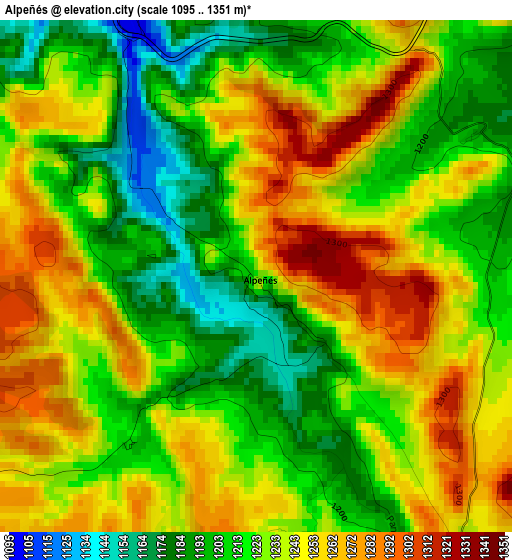
Below is the Elevation map of Alpeñés, which displays elevation range with different colors. Scale of the first map is from 1095 to 1351 m (3593 to 4432 ft) with average elevation of 1230.2 meters (=4036 ft) [note 1]
These maps also provides idea of topography and contour of this city, they are displayed at different zoom levels. More info about maps, scale and edge coordinates you can find below images.
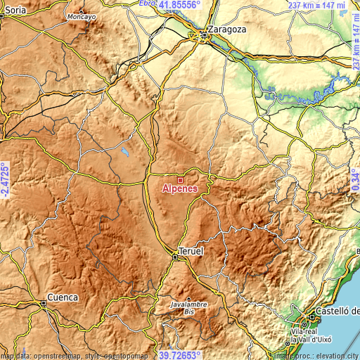
| \ | Map #1 | Topo.Map |
| Scale [m] | 1095..1351 m | × |
| Scale [ft] | 3593..4432 ft | × |
| Average | 1230.2 m = 4036 ft | × |
| Width | 7.4 km = 4.6 mi | 236.7 km = 147.1 mi |
| Height | 7.4 km = 4.6 mi | 236.7 km = 147.1 mi |
| ↑Max Latitude | 40.832838° | 41.85556° |
| Latitude at center | 40.79958° | 40.79958° |
| ↓Min Latitude | 40.766305° | 39.72653° |
| ← Min Longitude | -1.110195° | -2.4725° |
| Longitude center | -1.06625° | -1.06625° |
| →Max Longitude | -1.022305° | 0.34° |
Nearby cities:
Cities around Alpeñés sort by population:
• Visiedo elevation 1187 m
12.9 km,  191°
191°
• Bañón 1122 m
11.3 km,  292°
292°
• Torrecilla del Rebollar 1145 m
12.3 km,  357°
357°
• Barrachina 1049 m
12.4 km,  330°
330°
• Pancrudo 1247 m
5.2 km,  143°
143°
• Rillo 1273 m
10.4 km,  145°
145°
• Cosa 1193 m
7 km,  302°
302°
• Torre los Negros 1081 m
6.5 km,  335°
335°
• Lidón 1219 m
9.9 km,  203°
203°
• Rubielos de la Cérida 1230 m
12.8 km,  255°
255°
• Villanueva del Rebollar de la Sierra 1084 m
11.3 km,  25°
25°
• Fuenferrada 1118 m
9 km, 30°
Multilingual:
 En español:
Alpeñés elevación 1225 m.
 En France:
Alpeñés élévation 1225 m.
 Auf Deutsch:
Alpeñés höhe über dem Meeresspiegel ist 1225 m.

Sources and notes:
- [note 1] Map square and city borders are not equal. Map elevation data is calculated only from area inside that square.
- [src 1] Elevation data from geonames database provided with same terms of usage.
- [src 2] The elevation map of Alpeñés is generated using elevation data from NASA's 3 arcsec (90m) resolution SRTM data.
- [src 3] Base (background) map © OpenStreetMap contributors tiles are generated by Geofabrik and OpenTopoMap.
Copyright & License:
This Alpeñés Elevation Map is licensed under CC BY-SA. You may reuse any part from this page, if you give a proper credit by linking to this URL:
 More info on terms of use page.