Bañón elevation
Bañón (Aragon, Provincia de Teruel), Spain elevation is 1122 meters and Bañón elevation in feet is 3681 ft above sea level [src 1]. Bañón is a seat of a third-order administrative division (feature code) with elevation that is 519 meters (1703 ft) bigger than average city elevation in Spain.
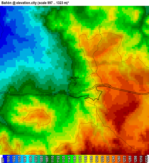
Below is the Elevation map of Bañón, which displays elevation range with different colors. Scale of the first map is from 997 to 1323 m (3271 to 4341 ft) with average elevation of 1161.5 meters (=3811 ft) [note 1]
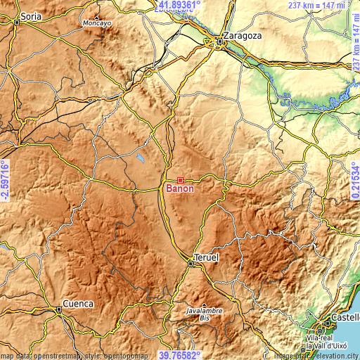
These maps also provides idea of topography and contour of this city, they are displayed at different zoom levels. More info about maps, scale and edge coordinates you can find below images.
| \ | Map #1 | Topo.Map |
| Scale [m] | 997..1323 m | × |
| Scale [ft] | 3271..4341 ft | × |
| Average | 1161.5 m = 3811 ft | × |
| Width | 7.39 km = 4.6 mi | 236.6 km = 147 mi |
| Height | 7.39 km = 4.6 mi | 236.6 km = 147 mi |
| ↑Max Latitude | 40.871489° | 41.89361° |
| Latitude at center | 40.83825° | 40.83825° |
| ↓Min Latitude | 40.804994° | 39.76582° |
| ← Min Longitude | -1.234855° | -2.59716° |
| Longitude center | -1.19091° | -1.19091° |
| →Max Longitude | -1.146965° | 0.21534° |
Nearby cities:
Cities around Bañón sort by population:
• Calamocha elevation 891 m
12.7 km,  315°
315°
• Monreal del Campo 946 m
14.9 km,  248°
248°
• Caminreal 925 m
11.2 km,  270°
270°
• Fuentes Claras 913 m
11.4 km,  284°
284°
• Torrijo del Campo 927 m
12.4 km,  263°
263°
• Torrecilla del Rebollar 1145 m
12.7 km,  51°
51°
• Barrachina 1049 m
7.9 km,  34°
34°
• Cosa 1193 m
4.6 km,  96°
96°
• Torre los Negros 1081 m
8 km,  78°
78°
• Lidón 1219 m
15 km,  153°
153°
• Rubielos de la Cérida 1230 m
7.7 km,  193°
193°
• Alpeñés 1225 m
11.3 km,  112°
112°
Multilingual:
 En español:
Bañón elevación 1122 m.
 En France:
Bañón élévation 1122 m.


Sources and notes:
- [note 1] Map square and city borders are not equal. Map elevation data is calculated only from area inside that square.
- [src 1] Elevation data from geonames database provided with same terms of usage.
- [src 2] The elevation map of Bañón is generated using elevation data from NASA's 3 arcsec (90m) resolution SRTM data.
- [src 3] Base (background) map © OpenStreetMap contributors tiles are generated by Geofabrik and OpenTopoMap.
Copyright & License:
This Bañón Elevation Map is licensed under CC BY-SA. You may reuse any part from this page, if you give a proper credit by linking to this URL:
 More info on terms of use page.